
Le MOPITT à vingt-cinq ans : un quart de siècle de science
– Par Paul Jeffery –
Le satellite Terra de la National Aeronautics and Space Administration (NASA), satellite phare du programme Earth Observing System (EOS) de la NASA,
– Par Paul Jeffery –
Le satellite Terra de la National Aeronautics and Space Administration (NASA), satellite phare du programme Earth Observing System (EOS) de la NASA,

– Par Stephanie Cleland –
Les changements climatiques entraînent une hausse des températures et une modification des conditions météorologiques à l’échelle du Canada et dans le monde.

– Par David Allan et Richard Allan –
De nombreuses personnes qui s’intéressent à l’océanographie ont déjà rencontré le blob froid ou « trou de réchauffement »,

– Par Emma Harrison –
« À cette date en 1988, je traversais le lac Melville en motoneige. J’espère me tromper complètement, mais tout indique que nous nous dirigeons vers une autre saison tardive. »
18 novembre 2023 — Derrick Pottle, observateur Nunatsiavut des glaces de mer pour Rigolet

– Par Yeechian Low –
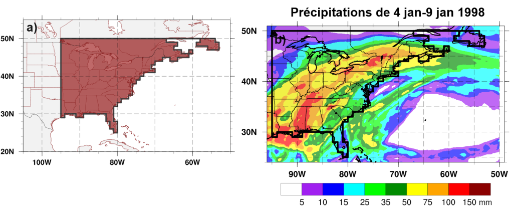

– Par Paul Joe, Ronald E. Stewart et Sudesh Boodoo –
Une analyse radar de la tempête de grêle du 13 juin 2020 à Calgary est présentée.

Du 3 au 6 juin 2024, le 58e congrès annuel de la Société canadienne de météorologie et d’océanographie s’est tenu virtuellement avec l’aide du Centre de Winnipeg et du Centre de l’intérieur de la Colombie-Britannique et du Yukon.

– Par Geoff Strong and Richard van der Jagt –
Le temps presse pour prendre le contrôle de notre climat avant qu’il n’atteigne un point de basculement, après lequel nous perdrons la possibilité de renverser la situation.

– Par Shanshan Zhong, Yuzhi Zhang et Leishan Jiang –
Le continent maritime (CM), situé dans la région tropicale (10°S-20°N, 90°E- 150°E), est le plus grand centre d’activité convective atmosphérique équatoriale dans le monde.