
Conséquences des différents types de développement de La Niña sur les précipitations dans le continent maritime
– Par Shanshan Zhong, Yuzhi Zhang et Leishan Jiang –
Le continent maritime (CM), situé dans la région tropicale (10°S-20°N, 90°E- 150°E), est le plus grand centre d’activité convective atmosphérique équatoriale dans le monde.
La chaleur latente de condensation libérée par les précipitations dans le CM fournit une énergie énorme aux circulations atmosphériques mondiales. Par conséquent, les anomalies de précipitations dans le CM ont un impact profond sur les conditions météorologiques mondiales et le changement climatique.
La variation des précipitations dans le CM est largement influencée par l’El Niño-oscillation australe (ENSO). Le signal ENSO pourrait induire des anomalies de vent zonal et de température de la surface de la mer (TSM) dans le CM en modifiant le gradient de TSM du CM vers le Pacifique tropical oriental, ce qui peut moduler davantage la circulation de Walker et entraîner des précipitations anormales dans le CM.
Des études antérieures ont montré que La Niña, c’est-à-dire la hausse de TSM froides sur le Pacifique tropical central et oriental (CETP), est favorable à l’augmentation des précipitations dans le CM. En revanche, peu d’études ont révélé les différences d’impact de la diversité dans les premiers stades de La Niña sur les précipitations dans le CM. En fait, le processus d’évolution des événements La Niña est diversifié. Certains événements La Niña sont transformés en événements El Niño et d’autres non, bien qu’ils présentent finalement des anomalies de TSM froides dans le Pacifique tropical central et oriental (CETP). Quels sont donc les principaux types d’évolution des événements La Niña? Existe-t-il des différences dans l’impact de la diversité du développement de La Niña sur les précipitations dans le CM? Ces questions scientifiques ne sont pas encore claires et seront étudiées dans l’article.
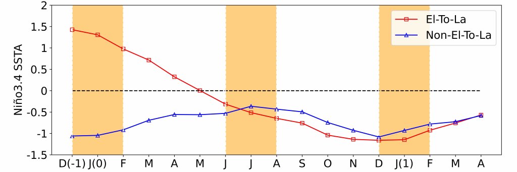
Les processus de développement des événements La Niña se manifestent principalement sous deux formes (figure 1). L’un est El-To-La, provenant de la transition d’El Niño au cours de l’hiver précédent, et l’autre est Non-El-To-La, évoluant à partir d’un état non-El Niño au cours de l’hiver précédent.
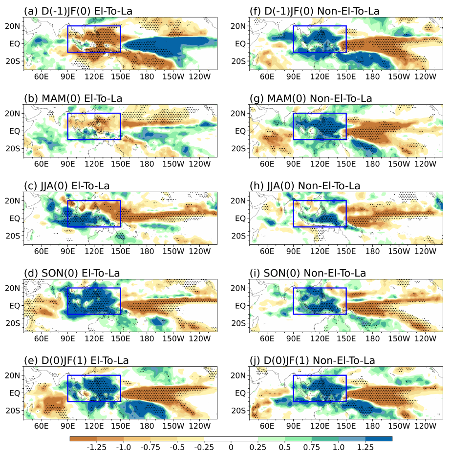
La figure 2 montre les anomalies de précipitations dans le CM de ces deux types de La Niña de l’hiver précédent à l’hiver en cours. De l’hiver précédent au printemps, en raison du contraste des TSM dans le CETP, les anomalies de précipitations dans la région du CM sont opposées pour deux types de développement de La Niña (figure 2a, b, f, g). Lorsqu’il y a des précipitations anormales positives (négatives) sur le CETP, la région du CM connaît surtout des précipitations anormales négatives (positives), ce qui est cohérent avec les études précédentes. En été boréal, les indices Niño3.4 deviennent négatifs, avec une intensité similaire, pour les deux types de La Niña (figure 1). Cependant, les anomalies de précipitations estivales dans le CM diffèrent entre ces deux types (figure 2c, h), avec des anomalies de précipitations positives couvrant la région sud du CM, centrées dans le sud-ouest du CM pour le type El-To-La (figure 2c), alors qu’elles sont confinées à la région sud-est du CM pour le type Non-El-To-La (figure 2h).
En été boréal, pour le type El-To-La, les anomalies locales de TSM sont positives dans toute la région du CM (figure 3c), ce qui crée un fort gradient de TSM entre le CM chaud et le CETP froid. La circulation zonale anormale de Walker associée au gradient zonal de TSM provoque des anomalies ascendantes uniformes sur la région du CM, favorisant des précipitations positives généralisées. Les anomalies locales de TSM chaudes et uniformes contribuent également à une humidité spécifique positive, ce qui renforce encore l’anomalie de précipitations. Par conséquent, les anomalies de précipitations positives s’étendent à toute la région du CM, centrées dans le sud-ouest du CM pour le type El-To-La. En revanche, pour le type Non-El-To-La, les anomalies de TSM ne sont positives que dans l’extrême est du CM et négatives dans l’ouest du CM (figure 3h). Malgré l’établissement d’une circulation de Walker à grande échelle entre le CM et le CEPT, la branche ascendante de la circulation de Walker est positionnée plus à l’est, ce qui entraîne une hausse des précipitations sur la région est du CM. Les anomalies de TSM locales et froides sur l’ouest de la région du CM entravent l’apport d’humidité et ne sont pas favorables à l’augmentation des précipitations. Par conséquent, les anomalies de précipitations positives ne se limitent qu’à la région sud-est du CM pour le type Non-El-To-La. Les simulations historiques des modèles climatiques ont encore vérifié les différents effets climatiques des précipitations dans la région du continent maritime causés par la diversité de l’évolution de La Niña (figure 4).
Cette étude est d’une importance significative pour comprendre les divers impacts de La Niña sur les précipitations dans la région du continent maritime et pour fournir des renseignements supplémentaires sur la prévision des précipitations dans la région du continent maritime.
– By Shanshan Zhong, Yuzhi Zhang, and Leishan Jiang –
Research motivation
The Maritime Continent (MC), located in the tropical region (10°S-20°N, 90°E- 150°E) , is the largest center of the equatorial atmospheric convective activity in the world. The condensational latent heat released by precipitation in the MC provides enormous energy for global atmospheric circulations. Therefore, the precipitation anomalies in the MC have a profound impact on the global weather and climate change.
The variation of precipitation in the MC is largely influenced by the El Niño-Southern Oscillation (ENSO). The ENSO signal could induce anomalous zonal wind and SST in the MC via altering the SST gradient from the MC to the tropical eastern Pacific, which can further modulate the Walker circulation and lead to anomalous precipitation in the MC.
Previous studies have shown that the La Niña, that is, the enhancement of cold SST over the central and eastern tropical Pacific (CETP), is favorable to enhanced precipitation in the MC. However, few studies have revealed the differences in the impact of diversity in the early stages of La Niña on precipitation in the MC. Actually, the evolution process of La Niña events shows diversity. Some La Niña events are transitioned from El Niño events and some are not, although they eventually exhibit cold SST anomalies in the CETP. Then, what are the main types of the evolution of La Niña events? Are there any differences in the impact of the diversity of La Niña development on precipitation in the MC? These scientific questions are still unclear and will be explored in the paper.
Conclusion
The development processes of La Niña events primarily manifest in two types (Fig.1). One is El-To-La (red line), originating from the transition of El Niño in the preceding winter, and the other is Non-El-To-La (blue line), evolving from a non-El Niño state in the previous winter.
Figure 2 shows the precipitation anomalies in the MC of these two types of La Niña from the preceding winter to the current winter. From the preceding winter to spring, due to the contrasting SST in the CETP, the precipitation anomalies in the MC region are opposite for two types of La Niña development (Fig. 2a, b, f, g). When there is positive (negative) abnormal precipitation over the CETP, the MC region is mostly negative (positive) abnormal precipitation, which is consistent with previous studies. In boreal summer, the Niño3.4 indices turn negative, with similar intensity, for both types of La Niña (Fig. 1). However, the summer precipitation anomalies in the MC differ between these two types (Fig. 2c, h), with positive precipitation anomalies covering the southern MC region, centered in the southwestern MC for the El-To-La type (Fig. 2c), while only confined to the southeastern MC region for the Non-El-To-La type (Fig. 2h).
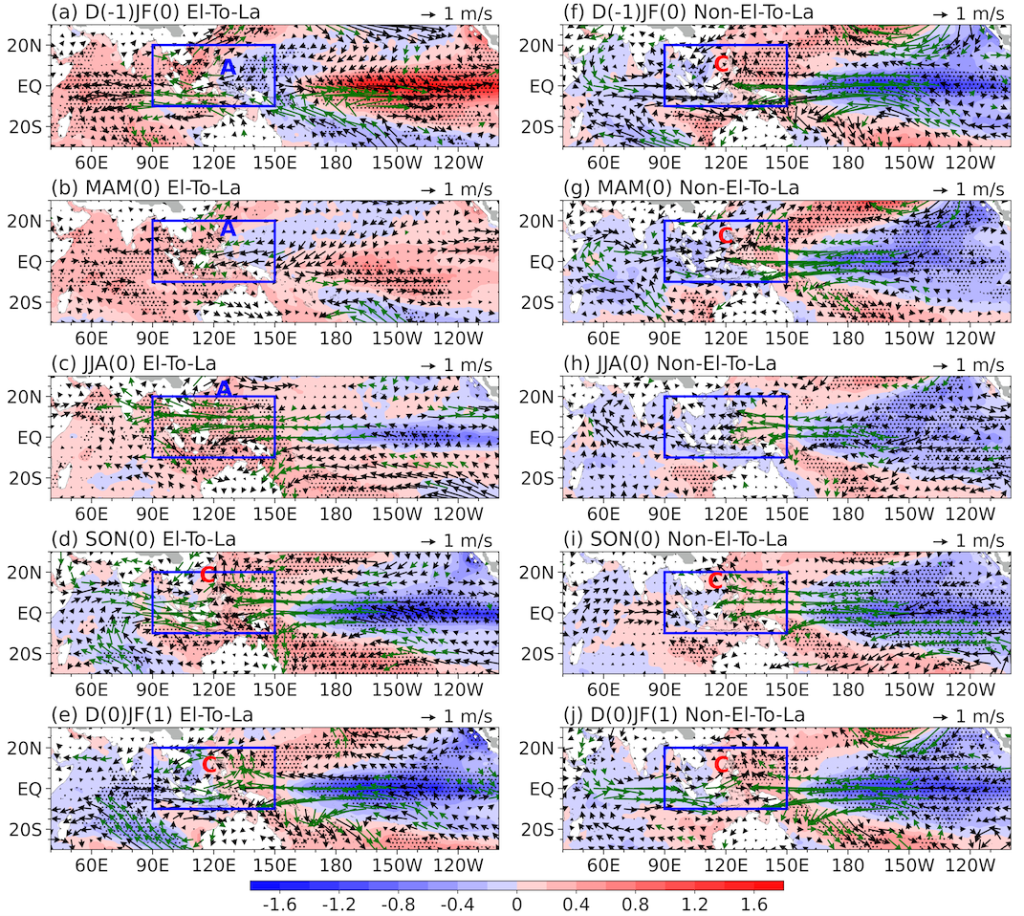
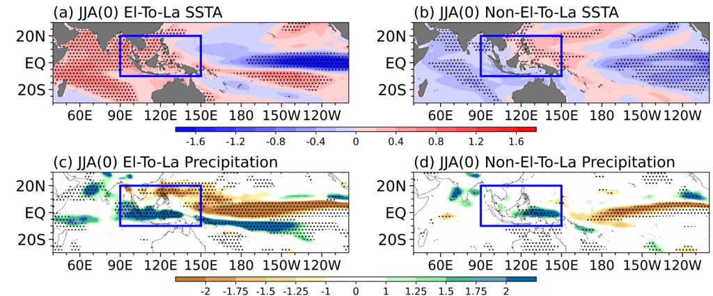
In boreal summer, for the El-To-La type, the local SST anomalies are positive in the entire MC region (Fig. 3c), which sets up a strong SST gradient between the warm MC and the cold CETP. The anomalous zonal Walker circulation associated with the zonal SST gradient causes uniform ascending anomalies over the MC region, promoting widespread positive precipitation. The local uniform warm SST anomalies also contribute to positive specific humidity, further enhancing the precipitation anomaly. Therefore, positive precipitation anomalies extend across the entire southern MC region, centered in the southwestern MC for the El-To-La type. Contrastingly, for the Non-El-To-La type, SST anomalies are only positive in the far eastern MC and negative in the western MC (Fig. 3h). Despite the establishment of large-scale Walker circulation between the MC and the CETP, the ascending branch of Walker circulation is positioned more to the east, resulting in increased precipitation over the eastern MC region. The local cold SST anomalies over the western MC hinder the moisture supply and are not favorable for precipitation enhancement. Therefore, the positive precipitation anomalies are only confined to the southeastern MC region for the Non-El-To-La type. The historical simulations of climate models have further verified the different climate effects of precipitation in the MC caused by the diversity of La Niña evolution (Fig. 4).
This study is of significant importance for understanding the diverse impact of La Niña on precipitation in the Maritime Continent region and providing additional information on the prediction of precipitation in the Maritime Continent region.
Dr. Shanshan Zhong is a professor of Nanjing University of Information Science and Technology (NUIST), located in Jiangsu, China. Her main research areas are climate impacts of the Tibetan Plateau thermal forcing, East Asian monsoon, and seasonal prediction of typhoon genesis frequency.
atmospheric circulation, el nino, ENSO, La Nina, Leishan Jiang, maritime continent, Précipitation, Shanshan Zhong, Yuzhi Zhang