
Prévisions saisonnières estivales 2020 de la glace de mer arctique
– Par des contributeurs de l’Environnement et Changement climatique Canada, l’Université du Québec at Montréal, l’Institut de l’Arctique et l’Antarctique, le Centre hydrométéorologique de Russie, l’Institut météorologique norvégien, l’Institut météorologique finlandais, l’Organisation météorologique mondiale, le Centre de prévision du climat, et l’Agence américaine d’observation océanique et atmosphérique –
Déclaration de consensus du Forum sur le climat de l’Arctique (suite)
Faits saillants
L’état des glaces inférieur à la normale à près de la normale pendant l’hiver 2019-2020 partout en Arctique est le résultat, entre autres, de températures de l’air en surface supérieures à la normale au-dessus de l’Eurasie et de l’océan Arctique.
La variabilité des prévisions de températures supérieures à la normale et des conditions plus humides que la moyenne dans les différentes régions de l’Arctique pour la période de juin à août 2020 contribue à la variabilité spatiale des prévisions de la débâcle printanière et de l’étendue minimale de la glace de mer pour l’été 2020.
Glace de mer
L’étendue maximale de la glace de mer dans l’hémisphère nord en mars 2020 était la 11e plus faible depuis 1979. La débâcle printanière devrait être plus précoce pour la majorité des régions de l’Arctique, à l’exception de la mer de Barents, de la mer du Groenland et de la moitié orientale de la baie d’Hudson, où l’on prévoit une débâcle plus tardive que la normale. On prévoit une étendue minimale de glace de mer inférieure à la normale pour 2020 dans la majorité des régions arctiques, à l’exception de la mer de Barents et la mer du Groenland où des conditions supérieures à la normale sont prévues.
Comprendre la déclaration de consensus
La déclaration de consensus comprend un résumé saisonnier et une vérification des prévisions de la glace de mer de la précédente saison hivernale 2020 (février, mars et avril), ainsi que les perspectives pour la prochaine saison estivale arctique de 2020 (juin, juillet et août). L’étendue de la glace de mer et les prévisions expérimentales d’engel se fondent sur le Système de prévision interannuelle et saisonnière canadien (SPISCanv2), un ensemble multi-modèles (MME) utilisant deux modèles climatiques. Un ensemble multi-modèles plus large qui inclura les prévisions des GPC-LRF suivants de l’OMM est en cours de développement : ECCC/SMC (SPISCanv2), NOAA (CFSv2), Météo-France (Système 5), MetOffice du R.-U (GloSea5) et CEPMMT (SEAS5). Lorsque l’étendue de la glace de mer est à son minimum en septembre de chaque année, il est possible d’obtenir les prévisions pour les mers périphériques suivantes dont la lisière des glaces varie : mer de Barents, mer de Beaufort, archipel arctique canadien, mer des Tchouktches, mer de Sibérie orientale, mer du Groenland, mer de Kara et mer de Laptev. Outre ces régions, il est également possible de prévoir la rupture de la glace de mer de la baie de Baffin, la mer de Béring, la mer de Sibérie orientale, la mer de Kara, la mer de Laptev, la mer des Tchouktches, la mer de Barents, la mer du Groenland, la baie d’Hudson et la mer du Labrador. Les perspectives estivales pour les principales zones de navigation proviennent de l’Institut de recherche sur l’Arctique et l’Antarctique et les Services des glaces canadien et finlandais, et sont fondées sur les indications de modèles statistiques et l’expertise en matière de prévisions.
Arctic Climate Forum Consensus Statement (Continued)
Highlights
Warmer than normal surface air temperatures over Eurasia and the Arctic Ocean contributed to below to near normal ice conditions during the 2019-2020 winter across the entire Arctic.
Forecast variability in above normal temperatures and wetter-than-average conditions across the different Arctic regions for June–August 2020 are contributing to the spatial variability in spring break-up and minimum sea ice extent forecast for the summer of 2020.
Sea-ice
The Northern Hemisphere March 2020 maximum sea-ice extent was the 11th lowest since 1979. Earlier than normal spring break-up is expected for the majority of the regions across the Arctic, with the exception the Barents Sea, Greenland Sea, and the eastern half of Hudson Bay, where a later than normal spring break-up is expected. Below normal 2020 minimum sea ice extent are forecast for majority of the Arctic regions; exceptions are above normal conditions forecast for the Barents and Greenland Seas.
Understanding the Consensus Statement
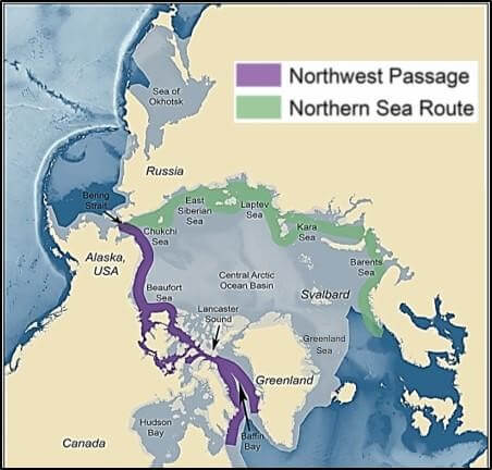
This consensus statement includes: a seasonal summary and forecast verification for sea-ice for previous 2020 Arctic winter season (February, March, and April 2020); an outlook for the upcoming 2020 Arctic summer season (June, July, and August 2020). Figure 1 shows the established shipping routes and regions used for the sea-ice products.
The sea ice extent and experimental freeze-up forecasts are based on the Canadian Seasonal to Inter-annual Prediction System (CanSIPSv2), a multi model ensemble (MME) of two climate models. A larger multi-model ensemble that will include forecasts from the following WMO GPC-LRFs is under development: ECCC/MSC (CanSIPSv2), NOAA (CFSv2), Meteo-France (System 5), UK MetOffice (GloSea5) and ECMWF (SEAS5). When sea ice extent is at its minimum in September of each year, forecasts are available for the following peripheral seas where there is variability in the ice edge: Barents Sea, Beaufort Sea, Canadian Arctic Archipelago, Chukchi Sea, Eastern Siberian Sea, Greenland Sea, Kara Sea, and Laptev Sea. In addition to these regions, forecasts for sea ice break-up are also available for Baffin Bay, Bering Sea, East Siberian Sea, Kara Sea, Laptev Sea, Chukchi Sea, Barents Sea, Greenland Sea, Hudson Bay, and Labrador Sea. Summer outlooks for key shipping areas are provided by the Arctic and Antarctic Research Institute, Canadian and Finnish ice services, and are based on statistical model guidance and forecast expertise.
Sea-Ice and Arctic Ocean
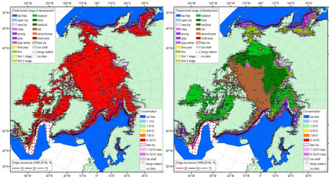
In general, high positive sea surface temperature (SST) anomalies and prevailing positive polar ocean upper layer (15m) heat content (HC) during October-December 2019 (MERCATOR Ocean reanalysis, not shown here) slowed freeze-up and sea ice growth in the Arctic. Weaker positive SST anomalies and neutral HC anomalies between January and March 2020 stimulated ice extent growth over the most of the Arctic region, while strong negative HC anomalies lead to close to normal ice growth in the Northern Barents Sea, Bering Sea and Sea of Okhotsk (Figure 2).
The 15.1 mln km2 maximum sea-ice extent reached on March 5, 2020 is the 11th lowest maximum sea-ice extent since 1979 (2019 – 7th), with the maximum winter sea ice extent observed in 1979 (16.77 mln km2). Nevertheless, estimates of the sea ice volume based on numerical reanalysis (HYCOM-CICE, PIOMAS) show that the 2020 sea ice volume was similar to that of 2019, a year with one of the lowest sea ice volume on records. Similarly, maximum winter ice thicknesses observed at coastal stations were in general significantly thinner on the Siberian side of the Arctic (up to – 50 cm for Kara Sea).
The effects of changing sea ice conditions in the boundary seas of the Arctic Ocean for winter 2020 included warmer and stormier weather conditions in the majority of the Arctic region, with the exceptions of Svalbard and Northern Greenland area who experienced colder and calmer conditions than normal.
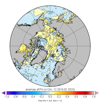
Figure 3 shows the MERCATOR Ocean pH anomalies for winter 2020, where areas of both positive (yellow areas: Arctic Basin and Chukchi Sea) and negative pH (blue areas: Barents, Kara Sea, and Canadian Arctic) anomalies can be identified. Such pH anomalies indicate possible effects of the different alkalization and acidification processes to Arctic marine wildlife.
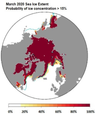
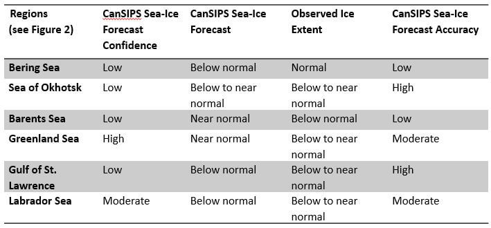
The forecast for March 2020 sea ice extent (Figure 4) was based on output from CanSIPSv2, an MME of two climate models and verified reasonably well for the Greenland Sea, the Gulf of St. Lawrence, and the Labrador Sea. Two regions, the Gulf of St. Lawrence and the Sea of Okhotsk, had a high forecast accuracy (right column,Table 1). Above normal air temperatures in Davis Strait and over the northern Labrador Coast suppressed ice growth during the past winter, leading to significantly lower ice export from these regions southward along the Labrador Coast and into the northwestern section of the Gulf of St. Lawrence. A near normal temperature regime was observed over the Gulf of St. Lawrence, but the lack of sea ice contributions from northern regions led to a lower than normal ice extent for the Gulf. Pronounced warm air temperature and low surface level pressure anomalies over the Barents and Greenland Seas for winter 2019-2020 restricted sea ice development as ice expansion was slowed by the lack of deep, sustained cold and the presence of regular destructive wind events. Relatively normal surface pressure and air temperature patterns over the Bering Sea and the Sea of Okhotsk supported near normal ice coverages.
Outlook for Spring Break-up 2020
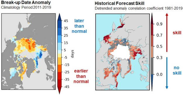
(Right) Figure 6. Historical forecast skill defined as the detrended anomaly correlation coefficient based on the 1981-2019 period.
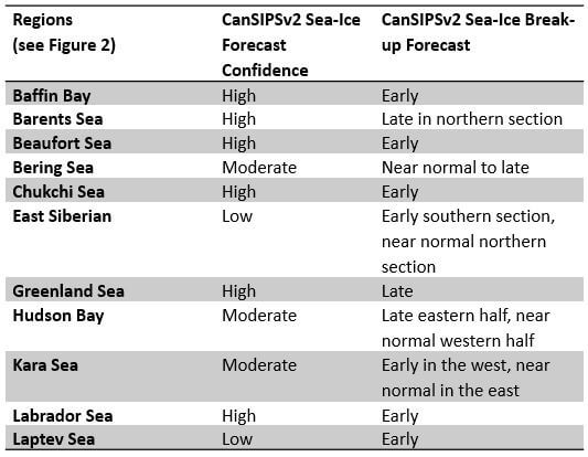
Sea ice break-up is defined as the first day in a 10-day interval where ice concentration falls below 50% in a region. The outlook for spring break-up shown in Figure 5 displays the sea ice break-up anomaly from CanSIPSv2 based on the nine-year climatological period from 2011-2019. The qualitative 3-category (high, moderate, low) confidence in the forecast is based on the historical model skill. Only regions where the model has historical skill are included in the outlook (Figure 6). A summary of the forecast for the 2020 spring break-up for the different Arctic regions is shown in Table 2.
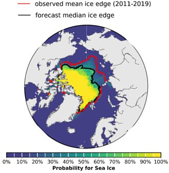
Outlook for September 2020 Minimum Sea Ice Extent
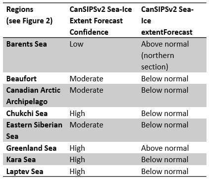
Minimum sea ice extent is achieved each year during the month of September in the northern hemisphere. Table 3 categorizes the sea ice extent forecast confidence and relative extent (i.e. near normal, below normal, above normal) with respect to a 2011-2019 climatology by Arctic region. Figure 7 displays the probabilities of ice presence for concentrations greater than 15% and the forecasted mean ice extent from CanSIPSv2 (black), with the observed median ice extent for the 2011-2019 period in red. The sea ice extent is expected to be below normal for the Beaufort Sea, Canadian Arctic Archipelago, Chukchi Sea, East Siberian Sea, Kara Sea and Laptev Sea, and above normal for the Barents and Greenland Seas.
Outlook for Key Shipping Regions
Northern Sea Route (NSR): Ice conditions are not expected to be problematic for the whole of the NSR during the spring and summer seasons in 2020. Currently observed below normal ice conditions, and projected above normal air temperatures and earlier than normal sea ice deterioration form the basis for this assessment. Light ice conditions will prevail throughout the sector and areas of landfast ice will break-up earlier than normal. Significant incursions of old ice are not expected along the route this summer season.
Northwest Passage: Break-up of sea ice is expected to be earlier than normal throughout the Northwest Passage this summer, and areas of consolidated ice will become mobile earlier in the season than normal. Ice conditions will be light in the southern route of the Northwest Passage in August 2020, with lessening ice conditions following in northern route by early September 2020. Anomalous concentrations of old ice are a potential hazard for the northern route and the western portion of the passage, as higher than normal amounts of old sea ice are present in these areas. Enhanced mobility of sea ice in the Canadian Arctic Archipelago could maintain elevated old ice concentrations in the aforementioned sectors throughout the summer 2020 period.
Baffin Bay: Early than normal sea ice break-up is forecasted for Baffin Bay this summer, due to current lower than normal ice extents in the region and predicted warmer than normal temperatures in the area of interest. Old ice concentrations in the bay are in line with climatological normal, and no specific hazards are anticipated. The presence of an ice bridge in Nares Strait well into this spring has cut off the inflow of old ice from the Arctic Ocean into northern Baffin Bay, thereby maintaining a limited influx of old ice into the region.
Hudson Bay/Hudson Strait: Faster than normal sea ice break-up is underway in Hudson Strait with significant areas of open water expanding in the northern portion of the strait this spring. Projections for ice break-up in Hudson Bay are more delayed than for the Hudson Strait, with near normal break-up expected for the western portion of the bay, and later than normal break-up in the eastern section. Ice thicknesses throughout Hudson Bay are notably thicker this spring than those observed in spring 2019, as predominantly thick first-year ice covers the western and central portions of the bay while in 2019, medium first-year ice comprised a significant fraction of the ice cover. This thicker ice coverage along with forecasted colder than normal surface air temperatures over Hudson Bay could lead to a more challenging navigation season, particularly in the eastern half of Hudson Bay.
Background and Contributors
This Arctic seasonal climate outlook was prepared for ACF-5. Contents and graphics were prepared in partnership with the Russian, United States, Canadian, Norwegian, Danish, Finnish, Swedish, and Icelandic meteorological agencies and contributions of the former JCOMM Expert Team on Sea-ice, former CCl/CBS Inter-Programme Expert Team on Regional Climate Activities, the GCW, the IICWG, and with input from AMAP.
The ArcRCC-Network, a collaborative arrangement with formal participation by all the eight Arctic Council member countries, is in demonstration phase to seek designation as a WMO RCC-Network, and its products and services are in development and are experimental. For more information, please visit https://arctic-rcc.org/acf-spring-2020.
Note from the Editor: this article accompanies the 2020 Arctic Seasonal Climate Outlook for Temperature and Precipitation, for which its introduction also applies to this piece.
Author & Affiliation List
- Gabrielle Gascon, Katherine Wilson, Marko Markovic (corresponding author), Scott Weese, Bill Appleby, Bill Merryfield, Michael Sigmond, Woosung Lee (Environment and Climate Change Canada, Canada)
- Arlan Dirkson (Université du Québec à Montréal)
- Vasily Smolyanitsky (Arctic and Antarctic Research Institute, Russia)
- Valentina Khan (Hydrometeorological Centre of Russia, Russia)
- Helge Tangen, Eivind Stoylen and Lene Ostvand (The Norwegian Meteorological Institute, Norway)
- Johanna Ekman (Finnish Meteorological Institute, Finland)
- Anahit Hovsepyan, Rupa Kumar Kolli (WMO)
- Arun Kumar and Shanna Combley (Climate Prediction Center, National Oceanic and Atmospheric Administration, USA)
Acronyms:
- AARI: Arctic and Antarctic Research Institute
- ArcRCC-Network: Arctic Regional Climate Centre Network
- ACF: Arctic Climate Forum
- AMAP: Arctic Monitoring and Assessment Programme
- CCl: WMO Commission for Clilmatology/
- CBS: WMO Comission for Basic Systems
- GCW: Global Cryosphere Watch
- GPCs-LRF: WMO Global Producing Centres Long-Range Forecasts
- IICWG: International Ice Charting Working Group
- LC-LRFMME: WMO Lead Centre for Long Range Forecast Multi-Model Ensemble
- NCAR: National Center for Atmospheric Research
- NCAR CFSR: National Center for Atmospheric Research Climate Forecast System Reanalysis
- NOAA/NWS/NCEP/CPC: National Oceanic and Atmospheric Administration/National Weather Service/National Centers for Environmental Prediction/Climate Prediction Center (United States of America)
- MME: Multi-model ensemble
- RCC: Regional Climate Outlook Forum
- WMO: World Meteorological Organization
- The Ice at the End of the World
- Seasonal Outlook for the spring 2020 (MAM) based on the official CanSIPS forecast issued on the 28th Feb. 2020
- Arctic Regional Climate Centre Consensus Statement: TEMPERATURE
- Seasonal Outlook for the winter 2019/2020 (DJF) based on the official CanSIPS forecast issued on the 30th Nov. 2019
More Like This
Déclaration de consensus du Forum sur le climat de l’Arctique, Forum sur le climat de l’Arctique, glace de mer de l'Arctique, Prévisions saisonnières estivales de climat