
Perspectives climatiques saisonnières d’été pour les températures et la précipitation dans l’Arctique 2020
– Par des contributeurs d’Environnement et Changement climatique Canada, the Arctic and Antarctic Research Institute, the Hydrometeorological Centre of Russia, The Norwegian Meteorological Institute, Finnish Meteorological Institute, World Meteorological Organization, Climate Prediction Center, et National Oceanic and Atmospheric Administration –
CONTEXTE
Le rythme d’augmentation des températures dans l’Arctique est plus de deux fois supérieur à la moyenne mondiale. Depuis les quatre dernières années (2016 à 2019), les températures annuelles de l’air à la surface dans l’Arctique (60°–85°N) ont été les plus chaudes de la série chronologique d’observations pour la période de 1936 à 2019.
La glace de mer hivernale n’a jamais atteint des niveaux aussi faibles, alors que le volume de la glace de mer présente dans l’Arctique en septembre 2019 a diminué de plus de 50 % comparativement à la valeur moyenne pour la période de 1979 à 20192. Pour soutenir les décideurs de l’Arctique confrontés à ces changements climatiques, le Forum sur le climat dans l’Arctique (FCA) récemment créé et convoqué par le Réseau de centres climatologiques régionaux pour l’Arctique (ArcRCC), sous l’égide de l’Organisation météorologique mondiale (OMM), présente des déclarations consensuelles relatives aux perspectives climatiques en mai avant le dégel et la débâcle d’été, ainsi qu’en octobre avant le gel hivernal et le retour de la glace de mer. Le rôle du réseau ArcRCC consiste à faciliter les services climatologiques régionaux axés sur la collaboration au sein des Services météorologiques et des glaces arctiques afin de résumer les observations, les tendances historiques, les modèles de prévisions, ainsi que pour combler les lacunes grâce à l’expertise régionale et produire ainsi des déclarations consensuelles au sujet du climat. Ces déclarations comprennent un examen des particularités climatologiques majeures de la saison précédente, ainsi que des perspectives pour la saison suivante en ce qui a trait à la température, aux précipitations et à la glace de mer. Les éléments des déclarations consensuelles sont présentés et font l’objet de discussions lors des séances habituellement en ligne du Forum sur le climat dans l’Arctique (FCA) avec les fournisseurs et les utilisateurs de l’information sur le climat dans l’Arctique, et ce, deux fois par année, soit en mai et en octobre. Cette déclaration consensuelle résulte de la 5e séance du FCA qui s’est déroulée en ligne les 27 et 28 mai 2020 sous la coordination du nœud eurasien du réseau ArcRCC organisé par la Fédération de Russie.
Arctic Climate Forum Consensus Statement
And Summary of the 2020 Arctic Winter Season
CONTEXT
Arctic temperatures continue to warm at more than twice the global mean. Annual surface air temperatures over the last 4 years (2016–2019) in the Arctic (60°–85°N) have been the highest in the time series of observations for 1936-2019. The extent of winter sea-ice is at record low levels, and the volume of Arctic sea-ice present in the month of September 2019 has declined by more than 50% compared to the mean value for 1979–2019. To support Arctic decision makers in this changing climate, the recently established Arctic Climate Forum (ACF) convened by the Arctic Regional Climate Centre Network (ArcRCC-Network) under the auspices of the World Meteorological Organization (WMO) provides consensus climate outlook statements in May prior to summer thawing and sea-ice break-up, and in October before the winter freezing and the return of sea-ice. The role of the ArcRCC-Network is to foster collaborative regional climate services amongst Arctic meteorological and ice services to synthesize observations, historical trends, forecast models and fill gaps with regional expertise to produce consensus climate statements. These statements include a review of the major climate features of the previous season, and outlooks for the upcoming season for temperature, precipitation and sea-ice. The elements of the consensus statements are presented and discussed at the Arctic Climate Forum (ACF) sessions with both providers and users of climate information in the Arctic twice a year in May and October, the later typically held online. This consensus statement is an outcome of the 5th session of the ACF held online on 27-28 May 2020 and coordinated by the Eurasian Node of ArcRCC-Network hosted by the Russian Federation.
HIGHLIGHTS
Warmer than normal surface air temperatures over Eurasia and the Arctic Ocean contributed to below to near normal ice conditions during the 2019-2020 winter across the entire Arctic. Forecast variability in above normal temperatures and wetter-than-average conditions across the different Arctic regions for June–August 2020 are contributing to the spatial variability in spring break-up and minimum sea ice extent forecast for the summer of 2020.
Temperature: The average surface air temperatures for FMA 2020 ranged from lower than normal in the western hemisphere to higher than normal in the eastern hemisphere, with Siberia experiencing one of its warmest FMA on record. Above normal temperatures are expected to continue across the majority of the Arctic for June–August 2020.
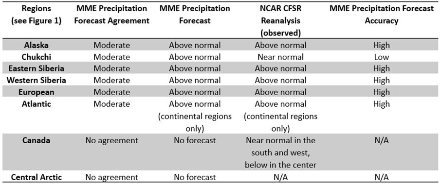
Precipitation: Wetter than average conditions during FMA 2020 were observed across the majority of the Arctic. Wetter than normal conditions are expected to continue across Alaska, and portions of the Chukchi, Eastern Siberia, and northern Canadian regions.
UNDERSTANDING THE CONSENSUS STATEMENT
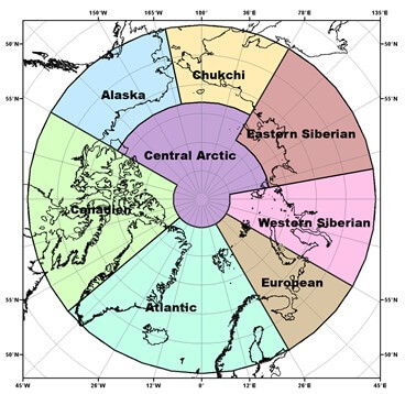
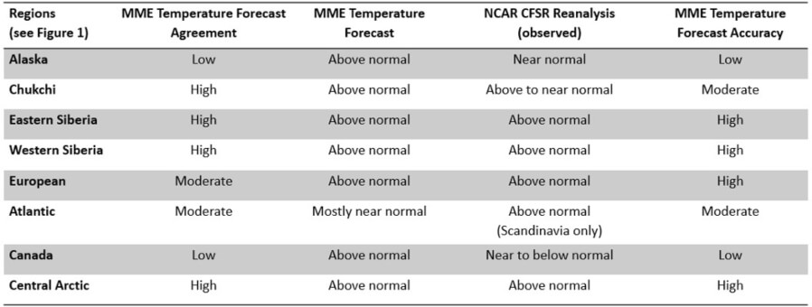
This consensus statement includes: a seasonal summary and forecast verification for temperature and precipitation for previous 2020 Arctic winter season (February, March, and April 2020); an outlook for the upcoming 2020 Arctic summer season (June, July, and August 2020). Figure 1 shows the regions that capture the different geographic features and environmental factors influencing temperature/precipitation.
The temperature and precipitation forecasts are based on eight WMO Global Producing Centers of Long-Range Forecasts (GPCs-LRF) models and consolidated by the WMO Lead Centre for Long Range Forecast Multi-Model Ensemble (LC-LRFMME). In terms of models’ skill (i.e. the ability of the climate model to simulate the observed seasonal climate), a multi-model ensemble (MME) approach essentially overlays all of the individual model performances. This provides a forecast with higher confidence in the regions where different model outputs/results are consistent, versus a low confidence forecast in the regions where the models don’t agree. The MME approach is a methodology well-recognized to be providing the most reliable objective forecasts.
TEMPERATURE
Summary for February, March, and April 2020:
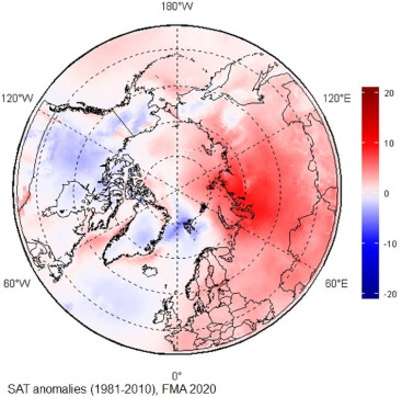
The February, March, and April (FMA) 2020 average surface air temperatures in the Arctic north of 65°N ranged from higher than normal in the eastern hemisphere, to lower than normal in the western hemisphere (Figure 2). Due to very low atmospheric pressure on the Eastern side of the Arctic (ERA5, not shown here), Scandinavia and the majority of the Eastern and Western Siberia regions experienced warmer than normal conditions (red areas in Figure 2), while the majority of Canada, Alaska, Greenland, and the North Atlantic Ocean experienced near normal (white areas in Figure 2) or slightly below normal (light blue areas in Figure 2) conditions. Using data from NCEP/NCAR reanalysis to rank the average surface air temperature, the boundary between Eastern and Western Siberia saw their second warmest FMA period, on average, since the start of the record in 1949 (not shown).
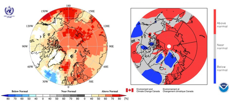
The FMA 2020 temperature forecast was verified by subjective comparison between the forecast (Figure 3, left) and re-analysis (Figure 3, right), region by region. A re-analysis is produced using dynamical and statistical techniques to fill gaps when meteorological observation are not available.
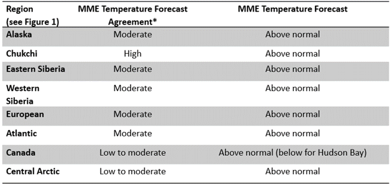
Above-normal surface air temperatures over the European, Eastern Siberia, Western Siberia, and Central Arctic regions were accurately forecast for the FMA 2020 season (Figure 3, Table 1). The forecast accuracies were variable over the Atlantic region, but near-normal temperatures over Iceland and parts of Greenland were accurately forecast. The observed near-normal temperatures over Alaska and the majority of Canada (grey areas on Figure 3, right) were not accurately forecast. Similarly, the observed below-normal temperatures over the Norwegian Sea and parts of Greenland (blue areas on Figure 3, right) were not accurately forecast. As a general conclusion, the multi-model ensemble forecast was accurate for approximately 50-60% of the Arctic territory.
Outlook for June, July, and August 2020:
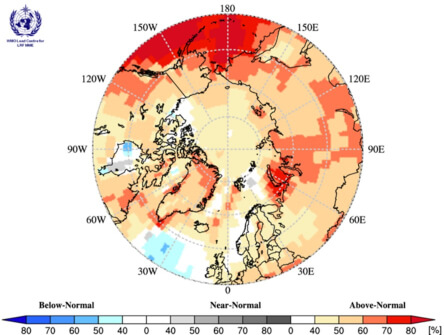
Surface air temperatures during summer 2020 (JJA: June, July, and August 2020) are forecast to be above normal across the majority of the Arctic regions (orange and red areas in Figure 4). The confidence of the forecast is low to moderate over the majority of the continental Arctic (land areas) (yellow and orange areas in Figure 4, Table 2), while forecast confidences are high for the maritime parts of the Atlantic region, the Bering Sea, and a portion of the Barents and Kara Seas (dark red areas in Figure 4, Table 2). The multi-model ensemble did not agree over a few maritime areas across the Arctic (white areas in Figure 4).
*: See non-technical regional summaries for greater detail
PRECIPITATION
Summary for February, March, and April 2020:
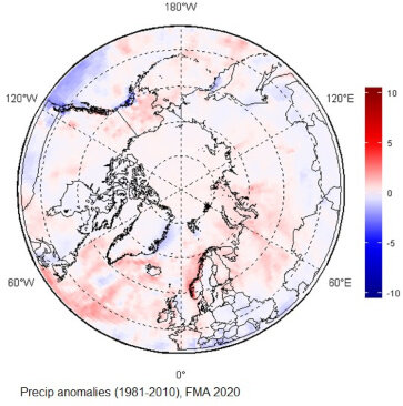
Wetter than average conditions were observed during February, March, and April (FMA) 2020 across the majority of Arctic region (red areas in Figure 5). Only a few isolated areas, including the northeastern coast of Greenland, northern Canada, and a small swath over southern Alaska, experienced drier than average conditions (blue areas in Figure 5).
The FMA 2020 precipitation forecast was verified by subjective comparison between the forecast (Figure 6, left) and re-analysis (Figure 6, right), region by region. As for temperature, precipitation re-analysis is produced using statistical techniques to fill gaps when meteorological observation are not available.
Above-normal precipitation over the majority of the Arctic were accurately forecast for the FMA 2020 season (Figure 6, Table 3). The only exception was the Chukchi area, where observed near-normal precipitation were inaccurately forecast. There was no agreement amongst the models over the Eastern Canada and Central Arctic region (predominance of white areas over those regions). As a general conclusion, the multi-model ensemble forecast was accurate for approximately 70% of the Arctic territory.
(Right): NCAR CFSR for precipitation for February, March, and April 2020.
Outlook for June, July, and August 2020:
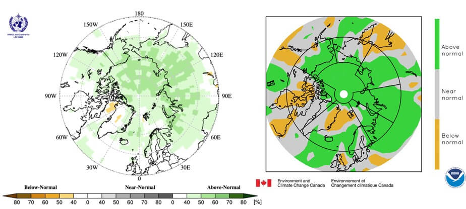
Precipitation during summer 2020 (JJA: June, July, and August 2020) is forecast to be above normal over Alaska, and portions and the Chukchi, Eastern Siberia, and northern Canadian region; the confidence of the forecast is low (light green areas in Figure 7, Table 4). A low confidence for below normal conditions is forecasted for a portion of Northern Atlantic (light orange areas in Figure 7, Table 4). The multi-model ensemble did not agree over the remainder of the Arctic region (white areas in Figure 7).

*: See non-technical regional summaries for greater detail
Background and Contributors
This Arctic seasonal climate outlook was prepared for ACF-5. Contents and graphics were prepared in partnership with the Russian, United States, Canadian, Norwegian, Danish, Finnish, Swedish, and Icelandic meteorological agencies and contributions of the former JCOMM Expert Team on Sea-ice, former CCl/CBS Inter-Programme Expert Team on Regional Climate Activities, the GCW, the IICWG, and with input from AMAP.
The ArcRCC-Network, a collaborative arrangement with formal participation by all the eight Arctic Council member countries, is in demonstration phase to seek designation as a WMO RCC-Network, and its products and services are in development and are experimental. For more information, please visit https://arctic-rcc.org/acf-spring-2020.
Author & Affiliation List
- Gabrielle Gascon, Katherine Wilson, Marko Markovic (corresponding author), Scott Weese and Bill Appleby (Environment and Climate Change Canada, Canada)
- Vasily Smolyanitsky (Arctic and Antarctic Research Institute, Russia)
- Valentina Khan (Hydrometeorological Centre of Russia, Russia)
- Helge Tangen, Eivind Stoylen and Lene Ostvand (The Norwegian Meteorological Institute, Norway)
- Johanna Ekman (Finnish Meteorological Institute, Finland)
- Anahit Hovsepyan, Rupa Kumar Kolli (WMO)
- Arun Kumar and Shanna Combley (Climate Prediction Center, National Oceanic and Atmospheric Administration, USA)
Acronyms:
- AARI: Arctic and Antarctic Research Institute
- ArcRCC-Network: Arctic Regional Climate Centre Network
- ACF: Arctic Climate Forum
- AMAP: Arctic Monitoring and Assessment Programme
- CCl: WMO Commission for Clilmatology/
- CBS: WMO Comission for Basic Systems
- GCW: Global Cryosphere Watch
- GPCs-LRF: WMO Global Producing Centres Long-Range Forecasts
- IICWG: International Ice Charting Working Group
- LC-LRFMME: WMO Lead Centre for Long Range Forecast Multi-Model Ensemble
- NCAR: National Center for Atmospheric Research
- NCAR CFSR: National Center for Atmospheric Research Climate Forecast System Reanalysis
- NOAA/NWS/NCEP/CPC: National Oceanic and Atmospheric Administration/National Weather Service/National Centers for Environmental Prediction/Climate Prediction Center (United States of America)
- MME: Multi-model ensemble
- RCC: Regional Climate Outlook Forum
- WMO: World Meteorological Organization
More Like This
Forum sur le climat dans l’Arctique, glace de mer de l'Arctique, Perspectives climatiques saisonnières, réseau ArcRCC, températures et precipitation dans l'Arctique