
L’importance des avant-dunes côtiers en tant que solution naturelle pour la protection du littoral : ce que nous apprend l’ouragan Fiona
Par Jeff Ollerhead, Robin Davidson-Arnott et Bernard O. Bauer
Les avant-dunes sont souvent présentés comme une solution naturelle pour empêcher l’inondation du littoral pendant les grosses tempêtes, ce qui permet d’atténuer les dommages potentiels aux précieuses infrastructures côtières et de réduire l’impact de l’érosion des vagues et des ondes de tempête. La destruction récente causée par l’ouragan Fiona (septembre 2022) sur la côte nord de l’Île-du-Prince-Édouard (Î.-P.-É.) offre une occasion idéale de valider cette affirmation.
Le changement climatique et le réchauffement des océans dans un avenir proche entraîneront trois conséquences prévues pour de nombreuses zones côtières canadiennes : i) une hausse des taux d’élévation du niveau relatif de la mer; ii) une augmentation de la fréquence et de l’ampleur des tempêtes majeures; et iii) une diminution de la couverture de glace de mer en hiver. Ces trois facteurs entraîneront une augmentation des taux d’érosion du littoral. Le sixième rapport d’évaluation du Groupe d’experts intergouvernemental sur l’évolution du climat (GIEC), l’organe des Nations Unies chargé d’évaluer les données scientifiques relatives au changement climatique, rend ces conséquences très claires, et Fiona illustre bien la tendance (figure 1).
Davidson-Arnott et Bauer (2021) ont récemment publié un article examinant les contrôles de la réponse géomorphique des systèmes plage-dune à l’élévation progressive du niveau de l’eau en lien avec d’autres contrôles à long terme de la réponse côtière (p`. ex. la climatologie du vent, la croissance de la végétation, le contexte géologique). La plupart des données donnent à penser que la plage et l’avant-dune (ainsi que le profil du littoral) peuvent migrer vers l’intérieur des terres de manière intacte, en suivant le rythme actuel de l’élévation relative du niveau de la mer (Fox-Kemper et coll. 2021). Cette situation peut toutefois être perturbée si la fréquence et/ou la gravité des tempêtes érosives augmentent. Cela réduira ou empêchera le système plage-dune de se rétablir dans une position vers l’intérieur des terres par le biais de l’apport de sable du littoral aux dunes dans des conditions de vagues de beau temps et de processus éoliens.
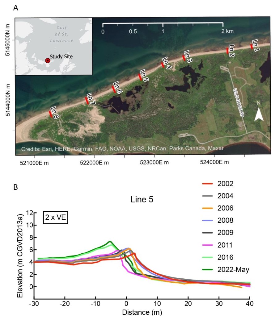
Un programme de recherche lancé il y a plus de 20 ans aux dunes de Greenwich (qui font partie du parc national de l’Î.-P.-É.; figure 2A) démontre que les dunes évoluent et migrent généralement vers l’intérieur des terres, comme l’ont laissé entendre Davidson-Arnott et Bauer (2021; figure 2B). Notre compréhension collective des processus en cause est éclairée par de multiples études sur le site, menées à diverses échelles spatiales et temporelles, du transport de sédiments vers les dunes pendant des événements éoliens individuels, à la variabilité saisonnière du transport de sédiments sur l’avant-dune, à l’évolution décennale du système d’avant-dunes au cours des 100 dernières années (p. ex. Walker et coll. 2017; Mathew et coll. 2010).
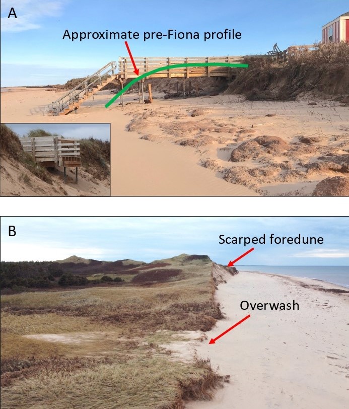
L’impact de Fiona sur le système plage-dune a été prononcé, avec l’érosion d’une partie importante du talus de la pente de l’avant-dune. L’intégrité des dunes est cependant restée largement intacte, et la crête des dunes n’a pas été rompue. La question qui se pose maintenant consiste à déterminer si l’avant-dune de Greenwich, et probablement d’autres endroits le long de la côte nord de l’Î.-P.-É., est susceptible de rester intacte dans un climat changeant. Il y a de l’espoir, car nous savons, grâce à des documents d’archives, que toute l’avant-dune de Greenwich a été érodée lors d’une importante tempête en 1923 et que le système d’avant-dune s’est complètement rétabli, bien que sur plusieurs décennies (Mathew et coll. 2010). Une question connexe est de savoir comment le système d’avant-dunes peut être géré pour avoir le plus de chances de « survivre » au changement climatique. Fiona donne un aperçu de ces deux questions.
-By Jeff Ollerhead, Robin Davidson-Arnott, and Bernard O. Bauer-
Introduction
Foredunes are oft-touted as a nature-based solution to preventing shoreline inundation during major storms, serving to mitigate potential damage to valuable coastal infrastructure and reducing the erosional impact of waves and storm surge. The recent destruction imparted by Hurricane Fiona (September 2022) on the north coast of Prince Edward Island (PEI) provides an ideal opportunity to validate this assertion.
Climate change and ocean warming in the near future will lead to three anticipated consequences for many Canadian coastal areas: i) an acceleration in rates of relative sea level rise, ii) an increase in the frequency and magnitude of major storms, and iii) a decrease in winter sea ice coverage. All three factors will drive increases in rates of shoreline erosion. The Sixth Assessment Report from the Intergovernmental Panel on Climate Change (IPCC), the United Nations body for assessing the science related to climate change, makes these consequences abundantly clear, and Fiona illustrates the trend nicely (Figure 1).
Davidson-Arnott and Bauer (2021) published a paper recently examining controls on the geomorphic response of beach-dune systems to progressive water level rise in relation to otherlong-term controls on coastal response (e.g., wind climatology, vegetation growth, geological context). Most of the evidence suggests that the beach and foredune (together with the nearshore profile) can migrate landward intact, keeping pace with current rates of relative sea- level rise (Fox-Kemper et al. 2021). This situation can be disrupted, however, if the frequency and/or severity of erosive storms increases. This will reduce or prevent the beach-dune system from re-establishing itself in a landward position via the delivery of sand from the nearshore to the dunes under fair weather wave conditions and aeolian processes.
A research program initiated more than 20 years ago at Greenwich Dunes (part of PEI National Park; Figure 2A) demonstrates that the dunes are generally evolving and migrating inland as suggested by Davidson-Arnott and Bauer (2021; Figure 2B). Our collective understanding of the processes involved is informed by multiple studies at the site, conducted at various spatial and temporal scales, from sediment transport to the dunes during individual wind events, to seasonal variability in sediment transport over the foredune, to the decadal evolution of the foredune system over the past 100 years (e.g., Walker et al. 2017; Mathew et al. 2010).
Hurricane Fiona – The Storm
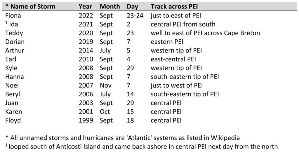
Although Atlantic hurricanes pass over or close to PEI every few years (Table 1), they are relatively infrequent events, with periods of several years without notable impacts (e.g., 2015-2018). By the time these warm-cored storms reach PEI, they have typically transitioned from their ‘hurricane’ or ‘tropical storm’ designation into an extra-tropical configuration with significantly reduced wind speeds, unless merging with mid-latitude cyclonic disturbances travelling through the region. Hurricane Fiona was not unusual in terms of its trajectory, extra- tropical status, and reduced wind speeds in the Maritimes, but its impact on the north coast of PEI was considerably more significant than any other tropical-origin storm in recent times.
Figure 3A shows the evolution of 4 (of 5) hurricanes to impinge on PEI since 2013, which is the period of record for the Stanhope weather station (ECCC ID#8300590-6545) which is representative of conditions on the north coast of PEI. Hurricane Ida is not included because it had slower windspeeds than the other four storms and tracked across PEI twice—once from the south and then from the north on the following day—after doing a loop in the Gulf and losing energy. It is evident that Fiona was the most significant storm during this decade, with winds peaking at 89 km h-1 and sustained winds above 60 km h-1 for 7 consecutive hours. A peak wind gust was recorded at 131 km h-1 just before midnight on September 23. An important factor for coastal impacts is that the wind was consistently out of the north for most of the storm, which lasted approximately 24 hours.
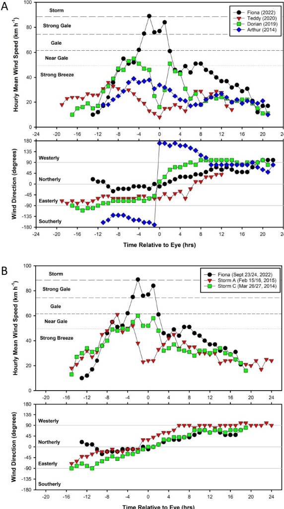
In contrast, the other three hurricanes shown in Figure 3A (Teddy, Dorian, and Arthur) were much less effective in their potential to cause shoreline erosion on the north shore of PEI. Dorian, for example, never reached ‘gale’ status (Beaufort Scale) and at its peak, had speeds of only 55 km h-1. Unlike Fiona, which tracked to the east of PEI, Dorian tracked almost directly over our field site. This meant that the wind in advance of the eye was generally from the east in the alongshore direction and then transitioned rapidly to a westerly direction (also alongshore but from the opposite direction) after the eye passed. Neither direction is conducive to wave generation or significant storm surge at Greenwich. Arthur and Teddy had greatly reduced wind speeds, never quite attaining 40 km h-1, and in the case of Arthur, the wind direction was dominantly from the south, consistent with its track across the western tip of PEI.
An assessment of all Atlantic hurricanes since 1953, using data from the Charlottetown Airport (YYG) weather station (ECCC ID#8300300-6526 and ID#8300301-50621; in continuous operation since 1953) indicates that Fiona was among the most intense hurricanes to hit PEI in three decades. The barometric pressure during Fiona was the lowest recorded at 95.85 kPa and the maximum hourly windspeed of 73 km h-1 ranks it third in intensity behind Hurricanes Juan (Sept 29, 2003; 82 km h-1; 98.55 kPa) and Arthur (Jul 5, 2014; 76 km h-1; 98.1 kPa). However, the inland location of Charlottetown airport means the windspeeds experienced on the north shore of PEI are often different. As shown in Figure 4A, the records from the Stanhope station show that the windspeeds during Fiona peaked at 89 km h-1 rather than the 73 km h-1 experienced at the airport. Moreover, the Stanhope station recorded a peak of only 39 km h-1 during Hurricane Arthur, rather than the 76 km h-1 experienced at the airport, which is due to the southerly wind direction during Arthur.
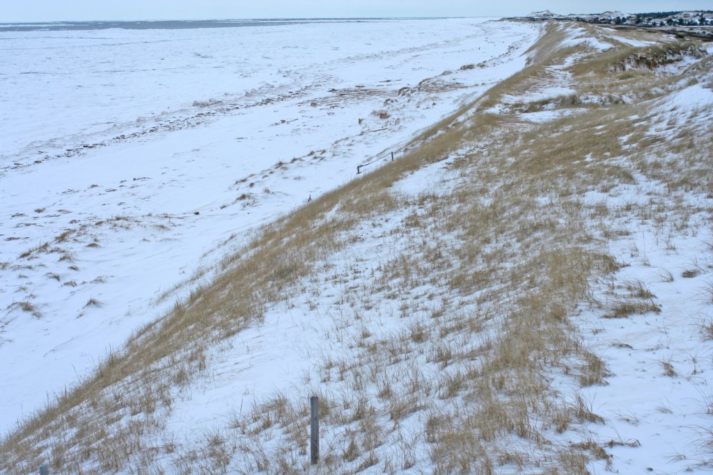
Even though Fiona stands out as one of the most intense Atlantic hurricanes to impact the north shore of PEI, there are other mid-latitude frontal systems that rival its intensity. A storm on March 12/13, 2022 had barometric pressures almost as low (96.24 kPa) as during Fiona, but windspeeds were below a ‘strong breeze.’ Figure 4B shows the evolution of Fiona relative to two of the most intense storms recorded at the Stanhope station since 2013. Storm A (Feb 15/16, 2015) attained peak windspeeds of 61 km h-1, which makes it the second-most intense wind event after Fiona. Storm C (March 26/27, 2014) was of similar intensity with peak windspeeds of 60 km h-1 and near gale conditions for 9 hours continuously. In the period 2014-2022, there were a total of thirteen storms that had peak windspeeds of 61 km h-1 or greater (based on Charlottetown data), only two of which were hurricanes (Fiona and Arthur). The other eleven storms had a mid-latitude origin and all occurred in the winter or early spring (i.e., December 15 through March 31). This is of considerable importance when assessing beach-dune interaction, because beach-dune systems on PEI are often covered by snow, and the north coast is protected from wave erosion by shore-fast ice, during this period (Figure 4). Thus, many of the most significant storms to hit PEI are incapable of forcing substantial shoreline change, despite their intensity, due to the presence of snow and shore-fast ice.
Hurricane Fiona – Beach-Dune Impacts
As noted above, an impact of Fiona was the erosion of a substantial portion of the stoss slope of the foredune along the Greenwich shoreline (Figures 5 and 2B). Our data also show, however, that landward retreat was less and preservation of the foredune greater at the western end of the study site, the downdrift end of the local littoral system. At the eastern end of the study site, the foredune is losing volume and retreating more rapidly.
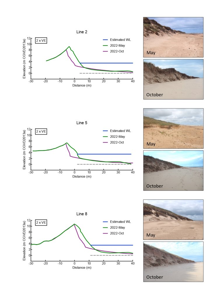
Much of the eroded sand during Fiona was lost to the nearshore, but a proportion was transported over the crest and onto the lee slope. Although it cannot be seen on Figure 5 given the scale, the data show a small increase in elevation on the lee slope from May to October 2022, and freshly deposited sand was evident there when surveying post-Fiona. Where the foredune was low, some sand moved inland by overwash (Figure 1B). Much of the sand that was moved to the nearshore zone will gradually make its way back to the beach-dune system driven by fair-weather waves and aeolian processes.
One challenge we faced in assessing Fiona and its impacts, is a lack of marine data for the north shore of PEI. Fisheries and Oceans Canada does not maintain any real-time tide stations on the north shore of PEI. Water level gauges operated by the Canadian Centre for Climate Change and Adaptation (CCCCA) at the University of Prince Edward Island at North Rustico and North Lake were not working properly during Fiona. The only estimate we could obtain was from CCCCA’s gauge at Red Head, which captured a peak storm surge of at least 2 m during Fiona. ECCC has no operational buoys in the Gulf of St. Lawrence to report on wind speed, wave height and period, atmospheric pressure, etc., so we are left to hindcast likely wave characteristics using terrestrial wind records. This situation is far from ideal, as researchers attempt to quantify the impacts of climate change in general, and storms in particular, in Maritime Canada.
The Future
As Figure 2 shows, over the past 20 years the foredune crest at line 5 has translated landward and grown vertically. Sand has been transported to the lee side, maintaining total dune volume. In short, the system is evolving in a manner consistent with the Davidson-Arnott and Bauer (2021) model, with the differences in erosion along the shoreline caused by Fiona explained by differing amounts of sediment available in the littoral cell. This observation highlights the need to assess beach-dune sediment balance in three dimensions along a stretch of coastal foredune (i.e., both on-offshore and alongshore) when assessing the robustness of a foredune to provide natural protection.
Based on our studies, it is anticipated that where there is sufficient sediment supply, sand ramp emplacement will take place relatively quickly and dune healing will occur. The increasing frequency and intensity of storms brought on by a warming climate may, however, disrupt the critical equilibrium between dune scarping and healing processes that have characterized this system for the last 50 years. As ocean temperatures warm, hurricanes and tropical storms will retain their intensity longer as they move north. This will likely be exacerbated by that fact that as sea ice (and particularly shore-fast ice) declines in the coming decades, winter events like Storm A (Feb 15/16, 2015) will become more effective in eroding the dunes. So, hurricanes reaching PEI will likely become more frequent and stronger (as suggested by Fiona) but the system will also be subjected to additional erosion from strong winter storms (i.e., Nor’easters) in the near future.
As Mathew et al.’s (2010) work demonstrates, the Greenwich beach-dune system can recover from even catastrophic erosion. Recovery from the storm of 1923 happened at a decadal scale, rather than at an annual scale, but it did happen. The management imperative is therefore to facilitate dune healing along this coast after major storms via natural processes by: 1) preventing human disturbance of the natural vegetation through activities such as trampling, driving of all-terrain vehicles, and construction; and 2) by providing substantial accommodation space for the foredune to migrate inland and grow upward as relative sea level rises. Management of the Greenwich Dunes by Parks Canada has employed this strategy, and our monitoring program indicates that it played an important role in the ability of the foredune there to withstand the impact of storm surge and erosion by large waves during the passage of Fiona.
Jeff Ollerhead is a Professor in the Geography and Environment Department at Mount Allison University in Sackville, NB. He is a coastal geomorphologist who studies beaches and salt marshes. In recent years, he has been particularly involved in designing and monitoring salt marsh restorations in the upper Bay of Fundy.
Robin Davidson-Arnott retired from the Department of Geography, Environment and Geomatics in 2009 and is now continuing research as Professor Emeritus. In addition to work on beach and nearshore sedimentation, he has carried out research on coastal salt marshes, erosion of cohesive coasts, particularly underwater erosion, beach/dune interaction, and the dynamics of coastal sand dunes. He has published extensively in book chapters and refereed journals, and his book Introduction to Coastal Processes and Geomorphology was published by Cambridge University Press in 2010 and a second edition in 2019.
Bernard Bauer is a process geomorphologist specializing in sediment transport dynamics in aeolian, nearshore, and fluvial systems. His research is primarily directed at advancing fundamental scientific understanding of Earth systems, but increasingly he is interested in ensuring that the latest scientific knowledge is used by coastal managers and environmental decision makers to inform policy development. Bauer is Emeritus Dean of Arts & Sciences at the University of British Columbia Okanagan.
References
Davidson-Arnott, R.G.D. and B.O. Bauer, 2021. Controls on the geomorphic response of beachdune systems to water level rise. Journal of Great Lakes Research, Vol. 47(6), p. 1594-1612. https://doi.org/10.1016/j.jglr.2021.05.006
Fox-Kemper, B., H.T. Hewitt, C. Xiao, G. Aðalgeirsdóttir, S.S. Drijfhout, T.L. Edwards, N.R. Golledge, M. Hemer, R.E. Kopp, G. Krinner, A. Mix, D. Notz, S. Nowicki, I.S. Nurhati, L. Ruiz, J.-B. Sallée, A.B.A. Slangen, and Y. Yu, 2021. Ocean, Cryosphere and Sea Level Change. In: Climate Change 2021: The Physical Science Basis. Contribution of Working Group I to the Sixth Assessment Report of the Intergovernmental Panel on Climate Change [Masson-Delmotte, V., P. Zhai, A. Pirani, S.L. Connors, C. Péan, S. Berger, N. Caud, Y. Chen, L. Goldfarb, M.I. Gomis, M. Huang, K. Leitzell, E. Lonnoy, J.B.R. Matthews, T.K. Maycock, T. Waterfield, O. Yelekçi, R. Yu, and B. Zhou (eds.)]. Cambridge University Press, Cambridge, United Kingdom and New York, NY, USA, pp. 1211–1362. https://www.ipcc.ch/report/ar6/wg1/
Mathew, S., R.G.D. Davidson-Arnott and J. Ollerhead, 2010. Evolution of a beach-dune system following a catastrophic storm overwash event: Greenwich Dunes, Prince Edward Island, 19362005. Canadian Journal of Earth Sciences, Vol. 47, p. 273-290. https://doi.org/10.1139/E09-078
Ollerhead, J. and R. Davidson-Arnott, 2022. Evolution and management of Atlantic Canadian coastal dunes over the next century. Physical Geography, Vol. 43(1), p. 98-121. https://doi.org/10.1080/02723646.2021.1936790
Walker, I.J., R.G.D. Davidson-Arnott, B.O. Bauer, P.A. Hesp, I. Delgado-Fernandez, J. Ollerhead and T.A.G. Smyth, 2017. Scale-dependent perspectives on the geomorphology and evolution of beach-dune systems. Earth-Science Reviews, Vol. 171, p. 220-253. https://doi.org/10.1016/j.earscirev.2017.04.011
Acknowledgements
Drs. I. Delgado-Fernandez, P.A. Hesp and I.J. Walker are thanked for their many contributions to this work over many years. The list of additional colleagues, students, and funding agencies who have contributed over 20 years is long and they too are thanked (see our published papers for a complete list).
avant-dunes, bernard bauer, Fiona, jeff ollerhead, robin davidson-arnott