
Tornades dans les Prairies canadiennes : 1826-1939
-Par Patrick McCarthy and Jay Anderson-
Résumé
Kendrew et Currie (1955) ont commenté les tornades des Prairies dans leur publication de 1955 intitulée The Climate of Central Canada : « … elles se produisent probablement en Alberta et au Manitoba, mais il n’y a pas de preuve définitive », tout en soulignant que la Saskatchewan n’en compte en moyenne qu’une par année. Après un effort exhaustif, nous avons compilé la base de données historique la plus complète sur les tornades des prairies canadiennes avant 1940. Celle-ci comprend un total de 589 tornades classées, dont 152 ont une trajectoire de dommages. Le projet a également permis d’obtenir un compte rendu plus complet des décès et des blessures dus aux tornades pour cette période.
Résultats
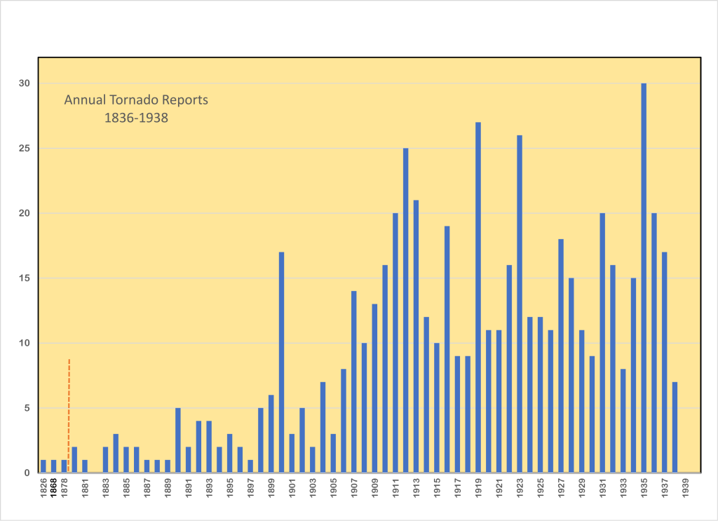
La plupart des premiers événements se sont produits dans les prairies de l’Est, plus peuplées. À partir des années 1880, des fermes agricoles et des communautés ont vu le jour le long des lignes de chemin de fer qui traversaient les plaines vers l’ouest. En 1900, le nombre de tornades signalées en Saskatchewan et en Alberta a commencé à augmenter considérablement (figure 1).
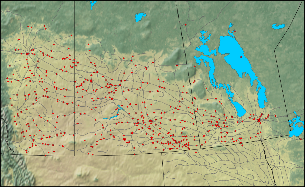
La présence de tornades de 1826 à 1939 se situe principalement au sud de la limite des arbres, dans la région des prairies (figure 2). Les rapports de tornades tracent souvent ces lignes de chemin de fer. Cet artefact est dû au fait que les rapports de tornades sont associés à une ville, un village ou une gare ferroviaire proche, même si la tornade peut avoir été assez éloignée. Ces distributions sont bien connues des prévisionnistes d’Environnement Canada, bien que les autoroutes aient remplacé les chemins de fer comme axe d’alignement. Les grandes caractéristiques climatologiques des tornades des Prairies sont apparues très tôt.
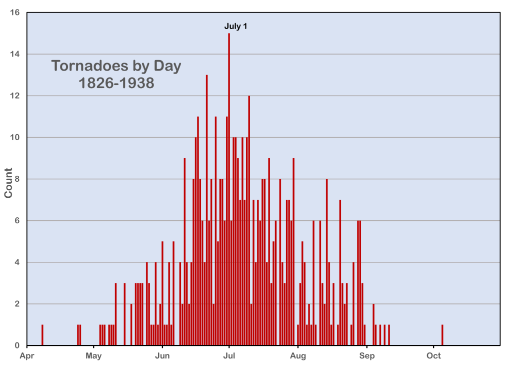
La figure 3 indique que le plus grand nombre de tornades est survenu de la mi-juin à la mijuillet. Les observations des tornades de fin de soirée et de nuit sont limitées par l’obscurité, un biais que nous avons tenté de surmonter en examinant la situation synoptique et les traces de dommages signalées. La latitude nord de la région signifie que le crépuscule civil se termine à 22 h 30 et commence à 4 h 30 du matin à la fin du mois de juin, ce qui ne laisse qu’une période de six heures d’obscurité au plus fort de l’été. Cette période pour les tornades observables est parmi les plus longues en Amérique du Nord.
La nature de la tornade des Prairies fait qu’il y a des variations stochastiques importantes dans les événements rapportés d’une année à l’autre, allant de zéro à 30 dans notre échantillon. Cela peut ou non représenter des différences dans les conditions climatologiques des années individuelles, car nous ne pouvons pas savoir à quel point notre échantillon est complet. Ce n’est que récemment, avec la popularité de la chasse aux tempêtes, des caméras des téléphones portables et des médias sociaux, que les comptes annuels de tornades ont commencé à refléter la fréquence réelle des événements de manière suffisamment proche pour en tirer une climatologie utile. Récemment, le Northern Tornadoes Project (2020) a démontré qu’un relevé intensif des dommages peut révéler un compte rendu plus complet des tornades et de leurs trajectoires.
De plus amples renseignements sur les efforts précédents, la méthodologie, les résultats ultérieurs et les travaux en cours sont disponibles en anglais ci-dessous.
-By Patrick McCarthy and Jay Anderson-
Abstract
Our project was to develop the most comprehensive and accurate database of Canadian prairie tornadoes. We have completed the period from 1826 to 1939. How this was accomplished is presented here.
Previous efforts
The systematic collection of Canadian prairie tornado events began with A.B. Lowe and G.A. McKay (1960). Brad Shannon (1976) extended that database to 1973. During the 1970s, the Prairie Weather Centre (PrWC) in Winnipeg established the Meteorological Service of Canada’s (MSC) first summer severe weather program. It was supported by the Regina Weather Office and was expanded to the Alberta Weather Centre. For verification and case study purposes, severe weather events, including tornadoes, were collected and archived for the three Prairie Provinces. These reports were often very incomplete, relying on informal contacts and phone calls to weather observers. At the time it was thought that sightings of only about 1/3rd of the tornadoes reached the weather office. In collaboration with the Ontario Weather Centre, damage surveys became a part of the PrWC records. Weather spotters were added to improve event detection and description. While the collection of annual events was ongoing, the archiving of historic occurrences remained very limited.
In the early 1980s, Dr. Keith Hage, at the University of Alberta, began an extensive study to identify historic Alberta and Saskatchewan tornado and windstorm occurrences. Michael Newark (1984) developed the first Canada-wide tornado database. His work would eventually include events as far back as the 18th century. Thomas Grazulis (1993) published an extensive American tornado dataset that included a few events that straddled the U.S.—Canada border. Hage (1994) published a second database for historic Alberta tornadoes, windstorms, and lightning fatalities. Dr. Alexander Paul (1995), at the University of Regina, produced a Saskatchewan tornado chronology from 1906 to 1991 (690 tornadoes). Grazulis (2000) published a compilation of Canadian “killer” tornadoes. Hage (2001) published his compilation of Saskatchewan tornadoes (720), windstorms, and lightning fatalities from 1880 to 1984.
While employed at the MSC office in Winnipeg, we began consolidating and correcting these sources, beginning in the early 1990s and continuing to the present. This effort formed the basis of the current MSC Prairie Severe Weather archive, and which is updated annually. Eventually, a formal version was made available to the public and researchers (McCarthy, 2010). The database contained roughly 19,000 severe convective events, including 3100 reported tornadoes dating back to 1826.
Methodology
We noted many problems in the 2010 database. These included vague reports, data gaps, unverified assumptions, missing and inaccurate dates and times, possible duplications, and conflicting death and injury totals. We undertook a project to review and update all the tornado reports in the archive and to add previously undiscovered events to the record.
We worked independently to take advantage of our unique but overlapping research approaches. In 2019, our two datasets were merged and differences in our records were resolved. This 1826-1939 portion of the review took about five years to complete. A small amount of new information has since been added; something that will likely occur on an ongoing basis.
The data-collection phase of the project had many challenges. Prior to 1940, there were no damage surveys, no video evidence, damage and tornado photographs were rare, eyewitness accounts were limited, and construction practices were varied. We are both experienced storm-damage surveyors and we used our experience to assess damage reports, leading to a subjective damage rating when sufficient evidence was available.
A multitude of sources, mostly unofficial and difficult to unearth, were used in the research. These included digital databases, particularly newspapers, books, historic school sources, community/rural municipality/county histories, historical societies, and obituaries. Most events appeared in newspapers, though there was typically little follow-up after the initial reports. Downed telephone and telegraph lines and poor roads often delayed the reports, leading to inaccurate dates in the record. Delayed information seldom made it into the newspapers, allowing initially bad information to linger in articles for weeks. To account for these issues, we searched for descriptions of events for up to a month after their occurrence, and in a few instances, much later.
Eyewitnesses have an expansive view across the open prairie. Tornadoes could be seen from long distances and reports often resulted in misplaced locations. The “highways” of the prairie were the railroads. Railway station names were often referenced, further misplacing the tornado’s position. Many stations and some communities have disappeared over time. We controlled many of these difficulties by triangulating available reports to narrow the location error. On days with multiple events, the information was plotted using eyewitness accounts, storm information, and damage characteristics, to identify storm damage swaths and potential tornado tracks. The numerical NOAA-CIRES 20th Century Reanalysis (V2c) ( https://psl.noaa.gov), displayed via the (https://meteocentre.com/) website, was also used to help assess storm types, potential storm motion, and storm potential. To validate a tornado occurrence, the authors used a decision-tree approach, similar to Sills, et al (2003).
A hybrid version of the Fujita (https://www.spc.noaa.gov/faq/tornado/f-scale.html) and Enhanced-Fujita Scales (https://www.spc.noaa.gov/faq/tornado/ef-scale.html) was used to rate tornado damage. The EFScale is too modern for most early events, which lack the necessary details in their descriptions. The FScale rating, which allows for a broader interpretation, was primarily used for the database. For events that crossed the U.S. – Canada border, the rating is for damage on the Canadian side, only.
The 1826-1939 timeframe was a period of immigration, spreading from east to west across the Northern Plains. There was a slow growth in population, communities, roads, railways, newspapers, etc., which affected the availability of data. For example, most cemeteries did not appear until after 1910 in Saskatchewan and Alberta.
One of our major goals was to provide a more complete account of the number of deaths and injuries. To make accurate casualty totals, a rigorous effort was made to identify the names of victims. This included victims who may have succumbed to the injuries well after the event. We used cemetery records, obituaries, ancestry/genealogy records, church records, provincial/state censuses, and death records to track down these victims.
Our effort has culminated in the most complete and descriptive archive of Prairie tornadoes and a record for researchers to build on. Some of our findings from this early compilation are presented in Part 2 of this series.
References
Grazulis, T.P., 1993. Significant Tornadoes, 1880-1991. Volume II: A Chronology of Events. Environmental Films, St. Johnsbury, VT. https://books.google.ca/books?id=yW5NAQAAIAAJ&printsec=frontcover&source=gbs_ge_summary_r& cad=0#v=onepage&q&f=false
Grazulis, T.P., 2000. Canadian Killer Tornadoes. The Tornado Project, St. Johnsbury, VT.
Hage, K.D., 1994. Alberta Tornadoes, Other Destructive Windstorms and Lightning Fatalities: 1879-1984. Self-published, Spruce Grove, Alberta, Canada.
Kendrew, Wilfrid George, and Balfour W. Currie, 1955. The climate of central Canada– Manitoba, Saskatchewan, Alberta and the Districts of Mackenzie and Keewatin. E. Cloutier, Queen’s Printer, Ottawa, 152.
McCarthy, P. (ed), 2011. Prairie and Northern Region 1826-2010 Severe Weather Event Database. Prairie and Arctic Storm Prediction Centre, Meteorological Service of Canada, Environment Canada, CD-ROM CD_095.
McKay, G.A., A.B. Lowe, 1960. The tornadoes of western Canada. Bull. Amer. Meteor. Soc., 41, No. 1, pp. 1-8. https://doi.org/10.1175/1520-0477-41.1.1
Newark, M. J., 1984: Canadian Tornadoes, 1950- 1979. Atmos.-Ocean, 22, 343-353.
Paul, A.H., 1995. The Saskatchewan Tornado Project. University of Regina, Department of Geography Internal Report.
Raddatz, R.L., R.R. Tortorelli, M.J. Newark, 1983. Manitoba and Saskatchewan Tornado days 1960 to 1982. Environment Canada, Atmospheric Environment Service, Canada Climate Centre, Downsview, ON, CLI-683, 57 pp.
Raddatz, R.L., J.M. Hanesiak, 1991. Climatology of Tornado Days 1960-1989 for Manitoba and Saskatchewan. Climatological Bulletin. 1991, 25, Num 1, pp. 47-59.
Shannon, T.B., 1976: Manitoba Tornadoes 1960-1973. Atmospheric Environment Service, Meteorological Applications Branch,
Environment Canada, Project Report No. 29. https://publications.gc.ca/collections/collection_2020/eccc/En57-46-29-eng.pdf
Sills, D.M.L., Scriver, S.J., and King, P.W.S. 2004. The tornadoes in Ontario project (TOP). Preprints, 22nd AMS Conference on Severe Local Storms, Hyannis, Mass., American Meteorological Society, CD-ROM 7B.5. http://www.yorku.ca/pat/research/dsills/papers/SLS22/SLS22_TOP_AMS.pdf
Abstract
Kendrew and Currie (1955) commented on prairie tornadoes in their 1955 publication The Climate of Central Canada: “…they probably occur in Alberta and Manitoba but there is no definite evidence,” while noting that Saskatchewan averaged only about one per year. After an exhaustive effort, we have compiled the most complete historical database of Canadian prairie tornadoes before 1940. This included a total of 589 rated tornadoes, with 152 having a damage track. The project also yielded a more complete account of tornado deaths and injured for the period.
Results
Most early events occurred in the more-populated eastern prairies. Beginning in the 1880s, agricultural farms and communities grew along the railway lines that were being laid westward across the plains. By 1900, there began a significant increase in tornado reports in Saskatchewan and Alberta (Figure 1).
The 1826-1939 tornado occurrences are mostly south of the tree line, spread across the prairie region (Figure 2). Tornado reports often trace out those railway lines. This artifact is due to tornado reports being associated with a nearby town, village, or rail station, even though the tornado may have been quite distant. These are well-known distributions to Environment Canada’s forecasters, though highways have replaced railways as the alignment axis. The broad climatological characteristics of Prairie tornadoes were evident from a very early stage.
Figure 3 shows that the largest number of tornadoes occurred from mid-June to mid-July. Observations of late evening and overnight tornadoes are limited by darkness, a bias that we attempted to overcome by examination of the synoptic situation and the reported damage tracks. The northern latitude of the region means that civil twilight ends at 10:30 pm and begins at 4:30 am in late June leaving only a six-hour period of darkness at the height of summer. This period for observable tornadoes is among the longest in North America.
It is the nature of the Prairie tornado that there are significant stochastic variations in reported events from year to year, ranging from zero to 30 in our sample. This may or may not represent differences in climatological conditions in individual years, as we cannot know how complete our sample is. It is only recently, with the popularity of storm chasing, cell phone cameras, and social media that annual tornado counts have begun to reflect the actual frequency of events closely enough to derive a useful climatology. Recently, the Northern Tornadoes Project (2020) has demonstrated that intensive damage surveying can reveal a more complete account of tornadoes and their tracks.
We estimated the strength of tornadoes according to a hybrid Fujita – Enhanced Fujita Scale, as described in our Part 1 article. The ability to come up with a definitive value is limited when information is sparse. Table 1 shows the distribution of our F-value estimates. The deficiency in F0 values is most likely due to their weak and transient nature, which makes them less likely to be observed, reported, or newsworthy. The data also suggests that deaths and injuries are more likely with stronger tornadoes.
Most early tornado reports contained only a single observation. Typically, only the more severe events included comments about the path location and length. Individual reports also tended to be limited by reference to a single nearby community. We endeavoured to be more precise by finding additional eyewitness accounts of each event that would allow a track to be established and by triangulating reports to obtain a more accurate position. From this improved dataset, we were able to estimate the tracks of 152 tornadoes in the pre-1940 era. In the case of the 1912 Regina tornado (Figure 4), we were able to find seven tornado tracks in the outbreak that day—a result that is comparable to the 1987 Edmonton tornado event.
One consequence of the research was the uncovering of additional events for inclusion into the severe weather database, including elements such as deaths due to lightning, major hail events, and unusual phenomena such as raining frogs and fish falling from the sky. In a few exceptional cases, a detailed assessment of extreme non-tornadic wind events, such as the 1922 Manitoba derecho, was constructed. These mesoscale convective systems often have embedded and difficult-to-detect tornadic circulations.
Ongoing work
As online digital databases continue to grow, we will likely see further adjustments to this early dataset. Moving forward, we are now examining the period from 1940 to 1979. The current database for this time frame contains over 900 possible tornado events. The goal is to have a comprehensive, reliable, accurate, and public dataset of tornadoes from the first reports on the Canadian Prairies to the present.
References
Kendrew, Wilfrid George, and Balfour W. Currie, 1955. The climate of central Canada– Manitoba, Saskatchewan, Alberta and the Districts of Mackenzie and Keewatin. E. Cloutier, Queen’s Printer, Ottawa, 152.
Sills, D. M. L., Kopp, G. A., Elliott, L., Jaffe, A. L., Sutherland, L., Miller, C. S., Kunkel, J. M., Hong, E., Stevenson, S. A., & Wang, W. (2020). The Northern Tornadoes Project: Uncovering Canada’s True Tornado Climatology, Bulletin of the American Meteorological Society, 101(12), E2113-E2132. Retrieved Oct 7, 2022, from https://journals.ametsoc.org/view/journals/bams/101/12/BAMS-D-20-0012.1.xml
Patrick McCarthy is a retired Meteorological Service of Canada meteorologist and former Head of the Prairie and Arctic Storm Prediction Centre. He is an active weather history buff, storm chaser, and the Chair of the CMOS Winnipeg Centre.
Jay Anderson is a meteorologist, formerly with Environment Canada, where he worked primarily in Winnipeg and Vancouver over a 34-year career. Since his retirement, he has been working casually as a consultant, primarily in the travel industry, and teaching storm chasing at the University of Manitoba