
Couverture de glace, stratification et mélange dans la mer de Kitikmeot de l’archipel Arctique canadien
– Par Chengzhu Xu et Qi Zhou –
La mer de Kitikmeot est une étendue ‘eau enfermée située entre l’île Victoria et la partie continentale du Canada, dans le sud de l’archipel Arctique canadien. Elle se compose (d’ouest en est) du détroit de Dolphin et Union, du golfe Coronation, du détroit Dease, du golfe Reine-Maud et du détroit de Victoria. Le golfe Coronation a une profondeur moyenne de 200-300 m et une période sans glace de la fin juin au début novembre chaque année, tandis que le golfe Reine-Maud a une profondeur moyenne de 100 m et une période sans glace relativement courte, soit d’août à octobre. En raison de l’existence de la période sans glace, la mer de Kitikmeot fait partie de l’itinéraire d’utilisation du passage du Nord-Ouest pour les navires traversant l’océan Arctique, bien que les seuils peu profonds du détroit de Dolphin et Union (environ 20 m) et le détroit de Victoria (30 à 40 m) présentent également des dangers pour la navigation. Néanmoins, avec le réchauffement du climat et la réduction de la couverture de glace, le trafic maritime augmente de manière significative dans les dernières années. À titre d’exemple, en 2010 seulement, 47 débarquements de navires de croisière ont été observés dans le passage du Nord-Ouest, soit une hausse de 57 % par rapport à 2006 (Stewart et Dawson, 2011). Les communautés côtières de la région de Kitikmeot bénéficient ainsi de grandes possibilités économiques, mais aussi de risques et de dangers pour l’environnement marin et l’écosystème local. Ici, nous discutons brièvement des conditions océanographiques physiques de la mer de Kitikmeot, selon des recherches appuyées par le réseau MEOPAR (Marine Environmental Observation, Prediction and Response).
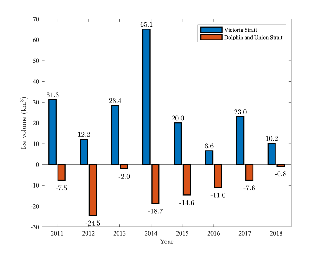
La mer de Kitikmeot est unique parmi les autres canaux de navigation de l’archipel Arctique canadien parce que 1) elle reçoit un apport massif d’eau douce par rapport à sa taille; 2) elle a des seuils de délimitation peu profonds aux deux extrémités; 3) elle a une courte saison sans glace chaque année. Les deux premières conditions entraînent une forte teneur en eau douce dans la mer de Kitikmeot et une stratification importante près de la surface de la mer (Williams et coll., 2018), tandis qu’en raison de la troisième condition, la stratification de la mer de Kitikmeot présente de fortes variations saisonnières fortement corrélées à la couverture de la glace de mer (Xu et coll., 2021). La densité de l’eau de mer est déterminée par la salinité et la température, bien que dans la mer de Kitikmeot, la salinité a un effet majeur sur la variation saisonnière de la densité près de la surface et donc sur la stratification. La plupart des apports d’eau douce dans la mer de Kitikmeot survient au début de la saison sans glace. L’eau douce provient de deux grandes sources. Tout d’abord, la plupart des rivières de la région de l’Arctique sont gelées tout au long de l’année, sauf en été. Cela provoque des ruissellements extrêmes pendant la crue printanière, généralement en mai et en juin, lorsque la salinité de la surface de la mer diminue considérablement. Une autre source importante, dont la contribution à la teneur en eau douce de la mer de Kitikmeot équivaut à un tiers de celle de l’écoulement fluvial, est la glace de mer (Xu et coll., 2021). Vers la fin de l’hiver (avril et mai), la glace de rive commence à se désagréger et à se mobiliser, dérivant avec le courant de surface. Bien qu’il existe des variations interannuelles, au cours d’une année type, l’écoulement se fait du détroit de Victoria vers le détroit de Dolphin et Union. Il en résulte un afflux net de glace de mer dans la mer de Kitikmeot par le détroit de Victoria, qui est relié aux chenaux couverts de glace pluriannuelle dans la partie nord de l’archipel Arctique canadien La glace dérivante constitue donc une voie importante de circulation de l’eau douce et diminue encore la salinité de la surface de la mer lorsqu’elle fond localement pendant l’été. Le rafraîchissement de l’eau de surface, combiné au réchauffement dû au rayonnement solaire direct, intensifie donc considérablement la stratification près de la surface au cours de la saison sans glace.
L’une des conséquences de la variation saisonnière de la stratification est qu’elle affecte fortement l’intensité du mélange vertical dans la mer de Kitikmeot (Afsharipour et coll., 2023). Généralement, l’intensité du mélange est faible au début de la saison sans glace, en raison de la forte stratification. Au cours de la saison sans glace, la tension du vent augmente lentement l’intensité du mélange et approfondit la couche mélangée de surface. Le mélange le plus fort se produit généralement au début de la saison des glaces, lorsque la tension du vent est combinée au refroidissement de l’eau de surface et à la formation de la glace de mer. Cette dernière expulse le sel des cristaux de glace, augmentant ainsi la salinité et donc la densité des eaux de surface. En conséquence, la stratification est affaiblie et le mélange est intensifié. Les mesures quantitatives donnent à penser que, sur la base de la moyenne mensuelle, l’intensité du mélange en octobre peut être supérieure de plus de deux ordres de grandeur à celle du mois de juillet.
La variation saisonnière de la couverture de glace, et donc de l’intensité de la stratification et du mélange, a plusieurs conséquences. Du point de vue de l’océanographie physique, le mélange vertical pourrait être l’un des principaux mécanismes à l’origine du renouvellement des eaux profondes dans la mer de Kitikmeot. Les seuils limitant le détroit de Dolphin et Union et le détroit de Victoria étant extrêmement peu profonds, l’afflux d’eau de fond dense sur ces seuils tend à être limité. Néanmoins, l’effet combiné de la baisse de température et de la hausse de la salinité au début de la saison des glaces augmenterait considérablement la densité de l’eau de surface, ce qui entraînerait une colonne d’eau faiblement stratifiée ou même non stratifiée L’eau dense coulerait alors et réalimenterait l’eau de fond. D’un point de vue biologique et écologique, les seuils peu profonds limitent également l’apport de nutriments dans le bassin versant dans la mer de Kitikmeot, tandis que l’intensification de la stratification estivale limite davantage les flux ascendants de nutriments dissous. Les effets combinés font de la mer de Kitikmeot l’une des masses d’eau les plus appauvries en azote de l’océan Arctique (Back et coll., 2021), limitant la production primaire et affectant par la suite l’ensemble du réseau trophique. Cela pourrait contribuer à l’absence de grands prédateurs, tels que les baleines et les ours polaires, que l’on trouve ailleurs dans l’Arctique.
– By Chengzhu Xu and Qi Zhou –
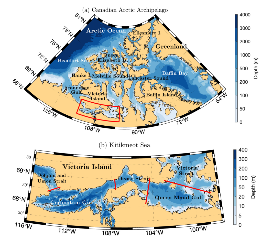
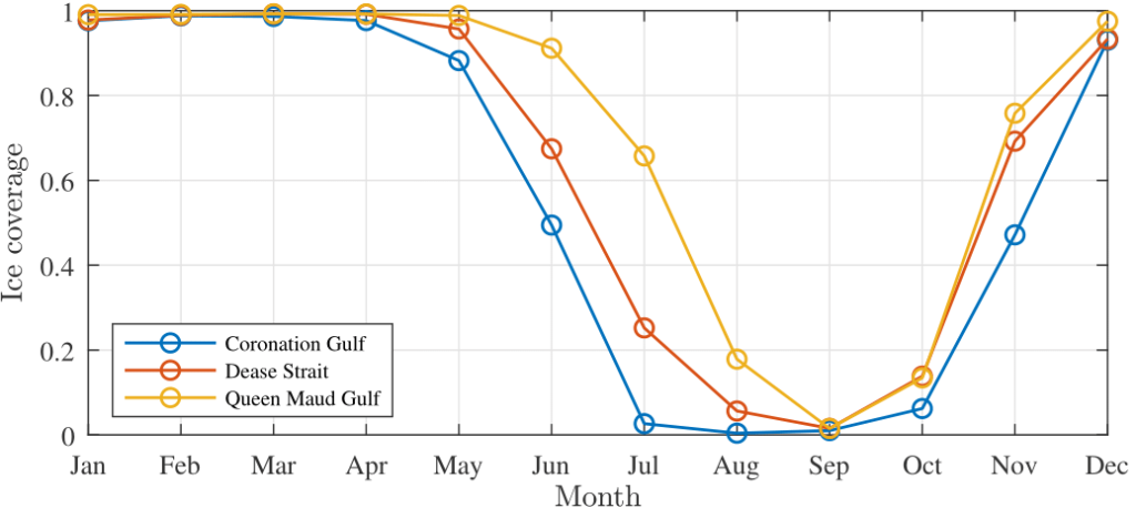
The Kitikmeot Sea (Figure 1) is a semi-enclosed water body located between Victoria Island and mainland Canada in the southern Canadian Arctic Archipelago (CAA). It consists of (from west to east) Dolphin and Union Strait, Coronation Gulf, Dease Strait, Queen Maude Gulf, and Victoria Strait. The Coronation Gulf has an average depth of 200–300 m and an ice-free period from late June to early November each year, while the Queen Maud Gulf has an average depth of 100 m and a relatively short ice-free period from August to October (Figure 2). Because of the existence of the ice-free period, the Kitikmeot Sea is part of the practical route of the Northwest Passage for vessels traversing the Arctic Ocean, though the shallow sills at Dolphin and Union Strait (about than 20 m) and Victoria Strait (30–40 m) also present dangers to navigation. Nevertheless, with the warming climate and reduced ice coverage, there is a significant increase in the shipping traffic in recent years. For example, in 2010 alone, the Northwest Passage experienced 47 cruise ship landings, a 57% increase from 2006 (Stewart & Dawson, 2011). This brings great economic opportunities to the coastal communities in the Kitikmeot region, but also risks and hazards to the marine environment and local ecosystem. Here, we briefly discuss the physical oceanographic conditions of the Kitikmeot Sea, based on research supported by the Marine Environmental Observation, Prediction and Response (MEOPAR) network.
The Kitikmeot Sea is unique among other channels in the CAA because 1) it receives massive freshwater input relative to its size, 2) it has shallow bounding sills at both ends, and 3) it has a short ice-free season each year. The first two conditions lead to a high freshwater content in the Kitikmeot Sea and a significant stratification near the sea surface (Williams et al., 2018), whereas due to the third condition, stratification of the Kitikmeot Sea exhibits strong seasonal variation that is highly correlated to the coverage of sea-ice (Xu et al., 2021). The density of sea water is determined by both salinity and temperature, though in the Kitikmeot Sea, the former has a major effect on the seasonal variation of the near-surface density and hence the stratification. Most of the freshwater input into the Kitikmeot Sea occurs in the beginning of the ice-free season. The freshwater content comes from two major sources. First, most rivers in the Arctic region are frozen solid throughout the year except in the summer. This causes extreme runoff events during the spring freshet, typically in May and June, when the salinity of the sea surface decreases dramatically. Another important source, whose contribution to the freshwater content of the Kitikmeot Sea is equivalent to as much as a third of that from river runoff, is the sea ice (Xu et al., 2021). In late winter (April and May), landfast ice starts to break down and mobilize, drifting with the surface current. Although inter-annual variation exists, in a typical year, the flow direction is from Victoria Strait to Dolphin and Union Strait. This leads to a net inflow of sea ice into the Kitikmeot Sea through the Victoria Strait (Figure 3), which is connected to channels covered by multi-year ice in the norther CAA. The drifting ice thus provides an important pathway of freshwater movement and further decreases the sea surface salinity when melting locally in the summer. The freshening of the surface water, combined with the warming due to direct solar radiation, thus significantly intensifies the near-surface stratification in the ice-free season.
One of the consequences of the seasonal variation of stratification is that it strongly affects the intensity of vertical mixing in the Kitikmeot Sea (Afsharipour et al., 2023). Typically, the mixing intensity is low in the beginning of the ice-free season, due to the strong stratification. During the ice-free season, the wind stress slowly increases the mixing intensity and deepens the surface mixed layer. The strongest mixing usually occurs in the beginning of the ice-covered season, when the effect of wind stress is combined with the cooling of surface water and the formation of sea ice. The latter expels the salt from ice crystal, thus increasing the salinity and hence the density of surface water. As a result, the stratification is weakened, and the mixing is intensified. Quantitative measurements suggest that, based on the monthly average, the mixing intensity in October can be over two orders of magnitude larger than that in July.
The seasonal variation of ice coverage, and hence the stratification and mixing intensity, has several implications. From a physical oceanographic point of view, vertical mixing could be one of the primary driving mechanisms for deep-water renewal in the Kitikmeot Sea. Because the bounding sills at Dolphin and Union Strait and Victoria Strait are extremely shallow, inflow of dense bottom water over these sills tends to be limited. Nevertheless, the combined effect of temperature drop and salinity increase in the beginning of the ice-covered season would significantly increase the density of the surface water, resulting in a weakly stratified or even unstratified water column. The dense water would then sink and replenish the bottom water. From a biological and ecological point of view, the shallow bounding sills also restrict the inflow of nutrients into the Kitikmeot Sea, while the intensified summer stratification further restricts the upward fluxes of dissolved nutrients. The combined effects cause the Kitikmeot Sea to be one of the most nitrogen-depleted water bodies in the Arctic Ocean (Back et al., 2021), limiting the primary production and subsequently affecting the entire food web. This could be a contributing factor to the lack of top predators, for example, whales and polar bears, that are found elsewhere in the Arctic.
Figures 1 and 2 are from an Original Manuscript of an article published in Atmosphere-Ocean on 2023, available online: https://wwww.tandfonline.com/10.1080/07055900.2023.2294210.
Chengzhu Xu is a postdoctoral researcher at the Oregon State University, USA. He is currently working on a project that aims to better represent tides in global ocean models. With the support from MEOPAR, he was involved in a research project studying the physical oceanography of the Kitikmeot Sea.
Qi Zhou is an associate professor in the Department of Civil Engineering at the University of Calgary. He was one of the recipients of the early-career research awards from MEOPAR which supported the modelling work reported in this article.
References
Afsharipour, Y., Xu, C., Myers, P. G., Else, B., & Zhou Q. (2023). Numerical investigation of diapycnal mixing of the Kitikmeot Sea in the southern Canadian Arctic Archipelago. Atmosphere–Ocean. https://doi.org/10.1080/07055900.2023.2294210
Back, D. Y., Ha, S. Y., Else, B., Hanson, M., Jones, S. F., Shin, K.-H., Tatarek, A., Wiktor, J. M., Cicek, N., Alam, S., & Mundy, C. J. (2021). On the impact of wastewater effluent on phytoplankton in the Arctic coastal zone: A case study in the Kitikmeot Sea of the Canadian Arctic. Science of the Total Environment, 764, 143861. https://doi.org/10.1016/j.scitotenv.2020.143861
Stewart, E. J., & Dawson, J. (2011). A Matter of Good Fortune: The Grounding of the Clipper Adventurer in the Northwest Passage, Arctic Canada. Arctic, 64(2), 263-267. https://doi.org/10.14430/arctic4113
Williams, W. J., Brown, K. A., Bluhm, B. A., Carmack, E. C., Dalman, L., Danielson, S. L., Else, B. G. T., Fredriksen, R., Mundy, C. J., Rotermund, L. M., & Schimnowski, A. (2018). Stratification in the Canadian Arctic Archipelago’s Kitikmeot Sea: biological and geochemical consequences. In 2018 Polar knowledge: Aqhaliat report (pp. 46–52). Polar Knowledge Canada.
Xu, C., Mikhael, W., Myers, P. G., Else, B., Sims, R. P., & Zhou, Q. (2021). Effects of seasonal ice coverage on the physical oceanographic conditions of the Kitikmeot Sea in the Canadian Arctic Archipelago. Atmosphere–Ocean, 59, 214–232. https://doi.org/10.1080/07055900.2021.1965531
Canadian Arctic Archipelago, Chengzhu Xu, Coronation gulf, ice coverage, Kitikmeot Sea, mixing, Qi Zhou, stratification