
Rapport de l’atelier scientifique CONCEPTS
– Par Smith, G.C., P. Pernica, Y. Lu, N. Soontiens, R. Horwitz, F. Dupont, M. Dunphy, Y. LeClainche, I. Gaboury, F. Davidson, C. Bourgault-Brunelle, A. Leroux, A. Holdsworth, D. Lavoie, R. Hourston, D. Schillinger, G. Sutherland, J.-P. Paaquin, H. Ritchie –
Le Réseau opérationnel canadien de systèmes couplés de prévision environnementale (ROCSCPE) a organisé un atelier scientifique du 17 au 27 octobre et du 9 au 10 novembre 2022. L’atelier a mis l’accent sur les quatre objectifs suivants : 1) l’état des systèmes de prévision du ROCSCPE et la pertinence de leurs produits pour les utilisateurs actuels du ROCSCPE; 2) la détermination des domaines potentiels d’amélioration des systèmes du ROCSCPE; 3) une évaluation des évolutions internationales qui pourraient être incorporées pour être utilisées dans les systèmes du ROCSCPE; et 4) le partage et l’alignement des plans de recherche et de développement entre les partenaires du ROCSCPE. Ce rapport présente un bref historique du ROCSCPE et un résumé des résultats de la réunion en personne d’une journée et demie, y compris certains domaines de recherche potentielle pour l’avenir.
L’océanographie opérationnelle a considérablement évolué au cours des 10 à 15 dernières années. Il existe aujourd’hui de nombreux systèmes de prévision mondiaux, régionaux et côtiers qui fonctionnent de manière opérationnelle dans tous les océans du monde. Ces systèmes s’appuient sur des chaînes sophistiquées de modélisation numérique, d’assimilation et de production de données pour fournir des renseignements fiables à diverses applications.
Les avantages potentiels d’une capacité opérationnelle de prévision océanique pour les applications du gouvernement du Canada ont été reconnus au début des années 2000 et ont mené à l’élaboration d’une initiative multiministérielle appelée ROCSCPE (Smith et coll., 2013a). Cet effort a d’abord impliqué Pêches et Océans Canada (MPO), Environnement et Changement climatique Canada (ECCC) et le ministère de la Défense nationale (MDN). Il a ensuite été élargi pour inclure la Garde côtière canadienne (GCC), le Conseil national de recherches (CNR) et l’Agence spatiale canadienne (ASC).
Il est difficile de résumer une réunion qui a couvert tant de domaines scientifiques différents, avec des discussions riches en renseignements dans chacun d’entre eux. Cela étant dit, plusieurs domaines clés ont été abordés à plusieurs reprises au cours de différentes séances et ont une incidence potentielle importante, ce qui justifie de les mettre en évidence ici. Les quatre domaines clés sont les prévisions concernant le littoral, les processus à petite échelle à l’interface air-mer, l’estimation de l’incertitude et la variabilité historique :
- Les prévisions concernant les zones littorales ont été fréquemment mentionnées au cours de plusieurs séances comme un besoin des utilisateurs pour la navigation électronique (c’est-à-dire l’application de modèles portuaires), mais aussi, plus largement, pour les interventions d’urgence et les besoins de soutien numérique des services de recherche et de sauvetage.
- Un autre domaine clé des futurs efforts scientifiques du ROCSCPE est l’amélioration des processus à petite échelle à l’interface air-mer. Par exemple, la couleur de l’océan et les concentrations de sédiments influencent la pénétration du rayonnement de courte longueur d’onde, ce qui a une incidence sur le contenu thermique de l’océan en surface, la stratification et le cisaillement près de la surface (et donc la dérive de surface).
- Un thème commun est apparu tout au long de la réunion : l’utilisation des produits du ROCSCPE et la manière de transmettre les erreurs aux groupes d’utilisateurs. Si les développeurs de systèmes connaissent la résistance des différents systèmes, la manière de partager ces renseignements avec les utilisateurs n’est pas claire. L’élaboration de nouvelles méthodes quantitatives pour résoudre ce problème a commencé. L’évaluation de la variabilité intrinsèque et l’utilisation d’ensembles pour échantillonner l’incertitude sont considérées comme deux premières étapes potentielles. Des estimations des erreurs systématiques dues à la résolution et à la physique du modèle sont également nécessaires. Un effort particulier dans ce domaine est nécessaire pour produire un produit permettant de communiquer la fiabilité aux utilisateurs.
- Ces dernières années, le ROCSCPE s’est concentré sur la fourniture d’analyses et de prévisions en temps quasi réel des conditions océaniques. Au fur et à mesure que ces systèmes et les besoins des utilisateurs évoluent, il est désormais clair que nous avons besoin de simulations historiques (prévisions rétrospectives et réanalyses) pour fournir un contexte aux anomalies actuelles. Cela pourrait permettre de mieux comprendre les incidences des événements extrêmes et aurait des avantages durables à long terme pour le ROCSCPE et la communauté scientifique canadienne et internationale.
En outre, une multitude de points scientifiques et techniques importants ont été soulevés et font l’objet d’une discussion sur les activités de collaboration et de coordination en cours. En particulier, un certain nombre de domaines d’activité du ROCSCPE été notés qui n’ont pas pu être entièrement explorés pendant le temps limité disponible pour l’atelier et qui bénéficieraient d’une discussion plus approfondie, y compris (mais sans s’y restreindre) la glace de mer, l’assimilation de données, les applications de modélisation biogéochimique, la gestion et la disponibilité des données d’observation, ainsi que la conception et la diffusion des produits du ROCSCPE. Des ateliers scientifiques à plus petite échelle, organisés régulièrement, pourraient être utiles pour continuer à faire avancer ces sujets scientifiques et d’autres.
– By Smith, G.C., P. Pernica, Y. Lu, N. Soontiens, R. Horwitz, F. Dupont, M. Dunphy, Y. LeClainche, I. Gaboury, F. Davidson, C. Bourgault-Brunelle, A. Leroux, A. Holdsworth, D. Lavoie, R. Hourston, D. Schillinger, G. Sutherland, J.-P. Paquin, H. Ritchie –
1. Introduction
The Canadian Operational Network of Coupled Environmental Prediction Systems (CONCEPTS) held a science workshop October 17-27 and November 9-10, 2022. The workshop focused on the following four objectives: 1) the status of CONCEPTS predictions systems and the fit-for-purpose of their products for current CONCEPTS users; 2) the identification of potential areas of improvement in CONCEPTS systems; 3) an assessment of international developments that could be incorporated for use in CONCEPTS systems; and 4) sharing and alignment of research and development plans between CONCEPTS partners. This report provides a brief background on CONCEPTS and a summary of outcomes from the 1.5-day in-person meeting including some areas for potential for future research.
2. CONCEPTS Background
Operational oceanography has matured considerably over the last 10 to 15 years. There are now numerous global, regional and coastal prediction systems running operationally across the world’s oceans. These systems are built on sophisticated numerical modelling, data assimilation and production chains to deliver reliable information for a variety of applications.
The potential benefits of an operational ocean forecasting capacity for Government of Canada applications was recognized in the early 2000s and led to the development of a multi-department initiative called CONCEPTS (Smith et al., 2013a). This effort initially involved Fisheries and Oceans Canada (DFO), Environment and Climate Change Canada (ECCC) and the Department of National Defense (DND). It was subsequently expanded to include the Canadian Coast Guard (CCG), the National Research Council (NRC) and the Canadian Space Agency (CSA).
Innovative science has been at the core of CONCEPTS efforts from its onset. The first CONCEPTS system was a ground-breaking effort to develop a two-way coupled atmosphere-ice-ocean forecasting system for the Gulf of St. Lawrence capable of improving operational numerical weather prediction forecasts through interactions across the air-sea interface (Pellerin et al., 2004; Smith et al., 2013b). This initiative was expanded to deliver the first global operational medium-range Numerical Weather Prediction (NWP) system with a 2-way coupled ice-ocean component (Smith et al., 2018).
This was followed by efforts to put in place a high-resolution sea ice forecasting capability to support Canadian responsibilities for METAREAS 17 & 18 as part of the Global Marine Distress and Safety System. This effort led to the development of the Regional Ice Ocean Prediction System (RIOPS; Dupont et al., 2015; Smith et al., 2021) and necessitated several innovations in sea ice analysis (Buehner et al., 2016) and a new parameterisation for landfast ice (Lemieux et al., 2015).
More recently, drift prediction and coastal modelling activities under the first phase of the Oceans Protection Plan (OPP) aimed to address needs for maritime safety and emergency response. This led to the development of ~2-3km grid resolution coastal prediction systems for the east and west Canadian coastlines (Paquin et al., 2023) together with a set of six port models to support needs for ocean prediction in areas of significant navigational risk and high maritime traffic. The development of these port models (Paquin et al., 2020; Dunphy et al., in prep.) required applying the Nucleus for European Modelling of the Ocean (NEMO) ocean model (used across other CONCEPTS systems) at extremely high sub-kilometer resolution. This capacity was demonstrated in a comparison with a coastal finite element model (Nudds et al., 2020). The skill of these systems in providing accurate drift estimates (and thus surface currents) was demonstrated by Soontiens et al. (in prep.).
Over the past 10 years, CONCEPTS has grown from an initial collaboration between three Canadian government departments interested in the potential benefits of coupled environmental prediction to an important inter-departmental Government of Canada collaboration with four fully-operational coupled atmosphere-ice-ocean prediction systems, global and regional ocean analysis systems, storm-surge and wave systems and port models along with numerous research projects and client systems making use of CONCEPTS innovations. Given the breadth of CONCEPTS applications, both within Government of Canada (e.g. DND, Canadian Hydrographic Service, CCG, Canadian Ice Services) and externally (e.g. Canadian Universities, Industry), there is a need to discuss and align research needs to best make use of available resources and identify gaps to provide the most useful and impactful environmental predictions and products.
3. CONCEPTS Science Workshop
A hybrid science workshop was organized spread over four weeks from Oct. 17 – Nov. 10, 2022. To include the maximum number of participants and minimize costs and environmental impacts, the meeting was split into nine 2-hr virtual sessions followed by a 2-day in-person meeting with a smaller group. The virtual sessions focused on the following topics:
- Overview of current systems with a focus on gaps and user needs
- Enabling service delivery
- Observations
- Biogeochemical prediction systems
- Drift observations and applications
- Future research and development plans
- Air-sea interactions
- Key innovations from beyond CONCEPTS
The virtual sessions included over 60 participants from ECCC, DFO, NRC, and CCG as well as from several Canadian Universities. There were also several international participants from Denmark and France. A number of key priority areas for further discussion were raised during the virtual session presentations and discussions. These areas were elaborated during the in-person meeting as mentioned below.
A final virtual session was held to summarize the previous sessions, identify gaps and areas for research and development coordination, and assist in planning the in-person meeting. It was noted by various participants how extensive and complex the various CONCEPTS research and development activities have become. The need for more active scientific exchanges was clearly highlighted by the fact that most of the virtual sessions had difficulty covering their topic within the 2hr timeslot.
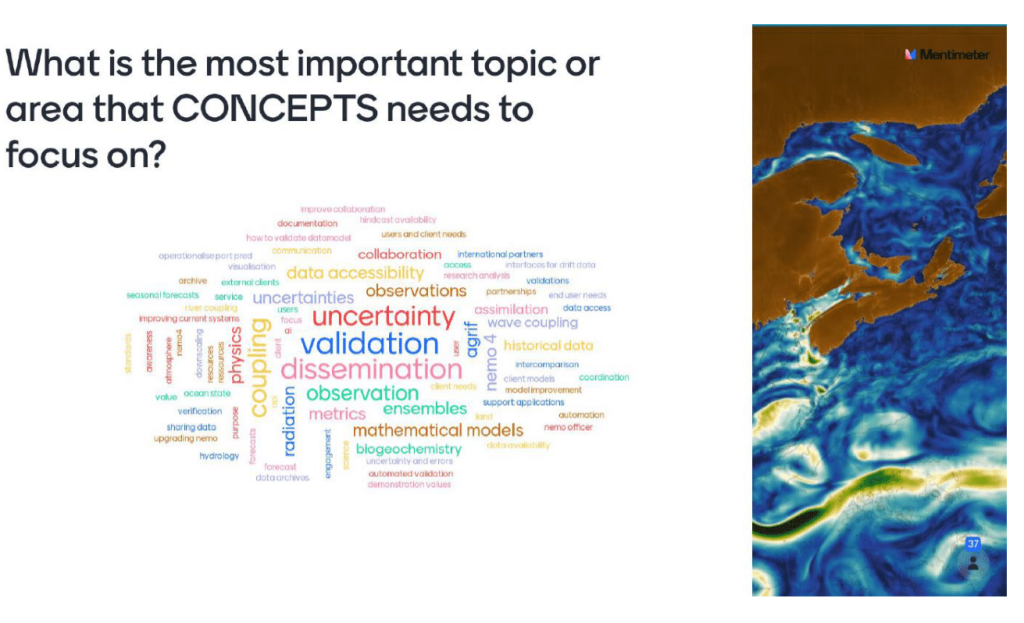
The second part of this session used an online application (mentimeter.com) to get feedback from participants that highlighted the various sessions were well appreciated, in particular the overview, observations, future plans and key innovations sessions. The question “What is the most important topic or area that CONCEPTS needs to focus on?” yielded a number of differing responses (Fig. 1), with product-related aspects showing up most frequently (validation, dissemination and uncertainty). The main objectives for the CONCEPTS products and services were identified as enhancing the documentation of products, facilitating cross-projects coordination in product generation as well as validating data access and format. The main challenges ad gaps for services appeared to be the development of partnerships, improvement of data discoverability, access to data near the coast, accessing archived data and managing the growing volume and diversity of data.
Following the virtual sessions, more in-depth discussions were held on Nov. 9 and 10 in a smaller in-person meeting at the Canadian Centre for Meteorological and Environmental Prediction (CCMEP) in Dorval. Based on outcomes from the virtual meeting, it was decided to focus on four specific topics: nearshore predictions, coordination on NEMOv4, observations and hindcasts/reanalysis.
4. Summary and CONCEPTS science challenges going forward
It is difficult to summarize a meeting that covered so many different scientific areas, with rich informative discussions in each. That being said, there are several key areas that surfaced on several occasions in different sessions and have a significant potential impact and thus warrant highlighting here. The four key areas are nearshore predictions, small-scale processes at the air-sea interface, uncertainty estimation, and historical variability:
- Nearshore predictions were mentioned frequently in several sessions as a user need for e-navigation (i.e., port model application) but also more broadly for Emergency response and Search and Rescue needs for numerical support.
- Another key area for CONCEPTS future science efforts is improvements in small-scale processes at the air-sea interface. For example, ocean colour and sediment concentrations are found to affect penetration of shortwave radiation thereby affecting surface ocean heat content, stratification and near-surface shear (and thus surface drift).
- A common theme arising throughout the meeting was the use of CONCEPTS products and how to convey error to user groups. While system developers have knowledge regarding strength of different systems, it is not clear how to share this information with users. Development of new quantitative methods to address this has begun. The assessment of intrinsic variability and the use of ensembles to sample uncertainty are seen as two potential first steps. Estimates of systematic errors due to resolution and model physics are also needed. A dedicated effort in this area is required to produce a product to communicate reliability to users.
- In recent years CONCEPTS has been focused on providing near-real time analyses and forecasts of ocean conditions. As these systems and user needs evolve, it is now clear that we need historical simulations (hindcasts and reanalyses) to provide context for current anomalies. This could provide a better understanding of impacts of extreme events and would have lasting long-term benefits for CONCEPTS and the Canadian and international scientific community.
In addition, there are a plethora of important scientific and technical points that were raised and for which ongoing collaboration and coordination activities are being discussed. In particular, a number of areas of CONCEPTS activity were noted that could not be fully explored during the limited time available for the workshop and which would benefit from further discussion, including (but not limited to) sea-ice, data assimilation, biogeochemical modelling applications, management and availability of observational data, and development and dissemination of CONCEPTS products. Regularly occurring, smaller-scale science workshops may be beneficial to continue to advance these and additional science topics.
Gregory Smith is a senior research scientist with Environment and Climate Change Canada (ECCC) based in Dorval QC. Greg leads a large research group in ECCC and is co-lead of the CONCEPTS Prediction Systems Working Group.
References
Buehner, M., Caya, A., Carrieres, T. and Pogson, L., 2016. Assimilation of SSMIS and ASCAT data and the replacement of highly uncertain estimates in the Environment Canada Regional Ice Prediction System. Quarterly Journal of the Royal Meteorological Society, 142(695), pp.562-573.
Dupont F., S. Higginson, R. Bourdallé-Badie, Y. Lu, F. Roy, G.C. Smith, J.-F. Lemieux, G. Garric, and F.
Davidson, 2015: A high-resolution ocean and sea-ice modelling system for the Arctic and North Atlantic Oceans, Geosci. Model Dev., 8, 1577-1594, doi:10.5194/gmd-8-1577-2015.
Lemieux, J.F., Tremblay, L.B., Dupont, F., Plante, M., Smith, G.C. and Dumont, D., 2015. A basal stress parameterization for modeling landfast ice. Journal of Geophysical Research: Oceans, 120(4), pp.3157-3173.
Nudds S, Lu Y, Higginson S, Haigh SP, Paquin J-P, O’Flaherty-Sproul M, Taylor S, Blanken H, Marcotte G, Smith GC, Bernier NB, MacAulay P, Wu Y, Zhai L, Hu X, Chanut J, Dunphy M, Dupont F, Greenberg D, Davidson FJM, Page F (2020) Evaluation of structured and unstructured models for application in operational ocean forecasting in nearshore waters. Journal of Marine Science and Engineering 8(7):484. 10.3390/jmse8070484
Paquin, J.P., Lu, Y., Taylor, S., Blanken, H., Marcotte, G., Hu, X., Zhai, L., Higginson, S., Nudds, S., Chanut, J. and Smith, G.C., 2020. High-resolution modelling of a coastal harbour in the presence of strong tides and significant river runoff. Ocean Dynamics, 70, pp.365-385.
Paquin, J.P., Roy, F., Smith, G.C., MacDermid, S., Lei, J., Dupont, F., Lu, Y., Taylor, S., St-Onge-Drouin, S., Blanken, H. and Dunphy, M., 2023. A new high-resolution Coastal Ice-Ocean Prediction System for the East Coast of Canada. EGUsphere, pp.1-38.
Pellerin, P., H. Ritchie, F. J. Saucier, F. Roy, S. Desjardins, M. Valin, and V. Lee, 2004: Impact of a two-way coupling between an atmospheric and an ocean-ice model over the Gulf of St. Lawrence. Mon. Wea. Rev., 132, 1379–1398, https://doi.org/10.1175/1520-0493(2004)132,1379:IOATCB.2.0.CO;2.
Smith, G.C., F. Davidson, and Y. Lu, 2013a: The CONCEPTS Initiative: Canadian Operational Network of Coupled Environmental Prediction Systems. The Journal of Ocean Technology, Vol. 8, No. 4.
Smith, G.C., Roy, F. and Brasnett, B., 2013b. Evaluation of an operational ice–ocean analysis and forecasting system for the Gulf of St Lawrence. Quarterly Journal of the Royal Meteorological Society, 139(671), pp.419-433.
Smith, G.C., Bélanger, J.M., Roy, F., Pellerin, P., Ritchie, H., Onu, K., Roch, M., Zadra, A., Colan, D.S., Winter, B. and Fontecilla, J.S., 2018. Impact of coupling with an ice–ocean model on global medium-range NWP forecast skill. Monthly Weather Review, 146(4), pp.1157-1180.
Smith, G.C., Liu, Y., Benkiran, M., Chikhar, K., Surcel Colan, D., Gauthier, A.A., Testut, C.E., Dupont, F., Lei, J., Roy, F. and Lemieux, J.F., 2021. The Regional Ice Ocean Prediction System v2: a pan-Canadian ocean analysis system using an online tidal harmonic analysis. Geoscientific Model Development, 14(3), pp.1445-1467.
Bedford Institute of Oceanography, CONCEPTS, DFO, ECCC, Institute of Ocean Sciences, Maurice Lamontagne Institute, Meteorological Service of Canada, Northwest Atlantic Fisheries Centre, Ocean Sciences Program, prediction systems, workshop