
Des planeurs sous-marins autonomes étudieront l’habitat des cétacés à fanons du bassin Roseway
– par T. Howatt(1) T. Ross(2), S. Waterman(1); 1: Université de la Colombie-Britannique, 2: L’institut des sciences de la mer –
Qu’est-ce qui rend idéal l’habitat essentiel de la baleine? Les eaux canadiennes contiennent un certain nombre d’habitats où les mysticètes s’alimentent. Le bassin Roseway est un tel habitat essentiel où la baleine noire de l’Atlantique Nord fourrage en quête de copépodes diapausants. Deux planeurs sous-marins autonomes ont été déployés dans le bassin Roseway au cours du mois d’août 2017 afin d’enquêter sur les mécanismes causant le regroupement de zooplancton faisant du bassin Roseway un habitat essentiel prospère. L’hypothèse proposée est que les fronts le long des marges du bassin, ainsi que la turbulence, jouent un rôle dans la création de régions concentrées de zooplancton. En ayant une meilleure compréhension de ce qui rend idéal l’habitat essentiel de la baleine, nous pourrons peut-être localiser d’autres habitats baleiniers et prendre des décisions averties quant à la façon de les protéger. Les planeurs sous-marins autonomes sont utilisés afin d’étudier les processus physiques qui affectent la distribution du zooplancton – la source primaire d’alimentation de la baleine noir de Nord Atlantique.
Canadian coastal waters are interspersed with baleen whale habitats, some of which are well known and protected, while others have yet to be identified and characterized.
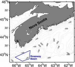
Figure 1: Map of Nova Scotian coastal waters (bathymetry in grey contours and depth in m) with Roseway Basin Critical Habitat outlined in blue.
The Whale Habitat and Listening Experiment (WHaLE), funded by Marine Environmental Observation Prediction and Response (MEOPAR), is an initiative dedicated to deepening our knowledge of rare and threatened baleen whales and helping to protect them from ship strikes. This project is a collaboration involving Dalhousie University, Fisheries and Oceans Canada, Ocean Tracking Network, University of Victoria, University of British Columbia, and Woods Hole Oceanographic Institute. A goal of this project is to use autonomous underwater gliders to identify and characterize baleen whale habitat in Canadian coastal waters.
Roseway Basin, NS (Figure 1) is a known and protected whale habitat: the Southeastern margin of the basin in particular has historically had a large number of right whale sightings [Vanderlaan et al., 2008; Davies et al., 2013]. What is it that makes Roseway Basin good habitat and why, in particular, is the Southeast margin favoured? There is still much to be learned about exactly what characteristics and/or oceanographic processes at play make this region attractive to whales, and why similar basins on the Scotian Shelf are less habited [Davies, et al., 2013; Moore, 2017].
Perhaps the whales are following the food; right whales primarily feed on diapausing Calanus finmarchicus (copepods) [Brown, et al., 2009], and fin whales are known to feed on euphausiids [Heise et al., 2007]. It is hypothesized that zooplankton aggregating processes, such as fronts [Franks, 1992] and/or turbulence [Fuchs and Gerbi, 2016], are occurring in the basin, making whale food abundant and highly concentrated.
Fronts, characterized by strong horizontal gradients in water properties, are known to typically be very biologically productive regions. This can be due to their role in segregating different water masses with different water properties and different zooplankton assemblages [Sournia, 1994; Powell and Ohman, 2015], or by creating plankton convergence zones through the interaction of the circulation associated with the front and certain zooplankton swimming behaviours [Franks, 1992].
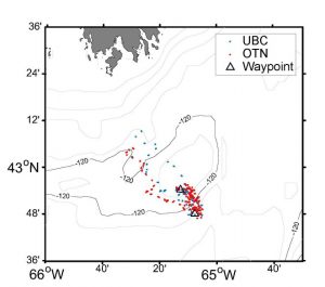
Figure 3: Map of 2017 glider tracks on Southeast slope of Roseway Basin.
The presence of enhanced ocean turbulence can have different effects on zooplankton distributions depending on the circumstance. In some cases, it supports zooplankton populations by increasing zooplankton feeding rates of smaller plankton, while in other situations, it stresses zooplankton populations by promoting zooplankton predation by larger organisms [Rothschild and Osborn, 1988]. Turbulence can also stress zooplankton by eroding the feeding currents they generate or by increasing their pursuit time of prey [Kiørboe and Saiz, 1995].
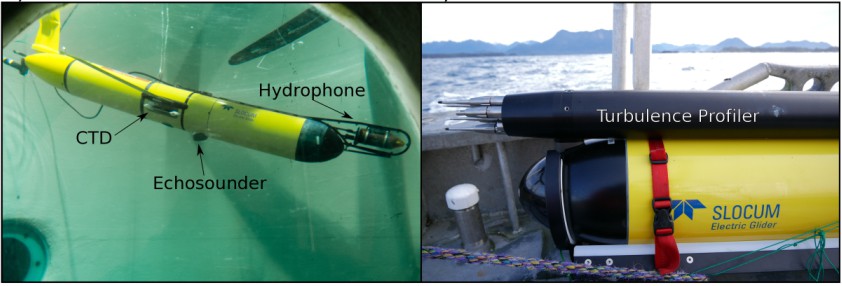
To examine the influence these physical processes have on the zooplankton distribution in Roseway Basin, we are using underwater gliders, autonomous drone-like instrument platforms which dive and climb in the water column, collecting data in a saw-tooth pattern for several days (Figure 2). Gliders are revolutionizing how we can observe the ocean by collecting substantial high-resolution, long-duration datasets of multiple ocean state metrics via a wide range of sensor payloads. This month we have had two such gliders deployed in the basin, doing repeated transects on the Southeast slope (Figure 3). One, operated by the Ocean Tracking Network (OTN), is equipped with a hydrophone to listen for whale calls, a 300 kHz echosounder to estimate zooplankton abundance, a CTD to measure temperature and salinity, an optode to measure dissolved oxygen concentration, and a series of optical sensors for measuring chlorophyll fluorescence, backscatter, and irradiance. A second glider, operated by the University of British Columbia (UBC, shown in header image), was also equipped with a CTD, oxygen sensor, and optical sensors for various biological proxies. In addition, it carries turbulent microstructure instrumentation to measure turbulence intensity.
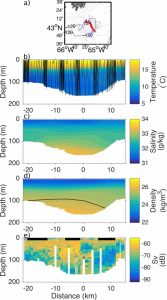
Figure 4: a) Map of 2015 Roseway Basin glider deployment in blue, cross-basin section used in b-e shown in red, b) conservative temperature with glider profiles superimposed, c) absolute salinity, d) density (colour) with 1025.5 kg/m3 isopycnal (black) superimposed, e) Scattering volume (Sv) with black bars at the top indicating nighttime sampling.
Glider measurements in Roseway Basin have been ongoing since 2014, but this is the first time a glider-mounted turbulence profiler has been used in this region. With strong tidal currents on the basin margin, we anticipate that this will be a very dynamic and turbulent region. Flying two gliders in tandem provides a unique opportunity to study the relationship between turbulence, zooplankton distribution, and whale presence. Further, past deployments have focused on mesoscale processes on scales of kilometers to tens of kilometers. This recent deployment has dedicated a week of sampling time to do repeated, shorter (13 km) transects of the Southeastern slope to characterize smaller scale processes like turbulence and submesoscale dynamics, and to capture the temporal variability of fronts.
On this mission, these two gliders have collected a total of 15 slope transects. We have observed density fronts indicated by the slope of the 1025.5 kg/m3 isopycnal (Figure 5), and the presence of dense water (>1026 kg/m3) that originates on the Scotian Slope and typically carries diapausing copepods [Head, et al., 1999; Davies et al., 2013]. We have observed that how the fronts are positioned on the basin slope varies due to the strong tidal currents in the area.
The UBC glider was recently successfully recovered, while the OTN glider is continuing to sample the full extent of the basin for another three months. When it’s done, the two gliders together will deliver a unique data set that allows us to study both meso- and submeso-scale processes in Roseway Basin, and further work towards bridging the gap between physical and biological oceanography.
Acknowledgements: We would like to thank Adam Comeau, Jude Van der Meer, Sue L’Orsa, and Richard Davis from the Ocean Tracking Network for all the hard work they put into the glider deployments. We also appreciate the work of Chris Payne and Benjamin Scheifele on the UBC glider team. We also thank Kim Davies, Hansen Johnson, and Chris Taggart for their expertise and leadership on the East coast WHaLE project. We thank Gennavieve Ruckdeschel for providing the echosounder data used in Figure 4. This work is funded by MEOPAR and 20 partnering organizations, which are listed here: http://meopar.ca/research/project/whale-whales-habitat-and-listening-experiment.
References
Brown, M. W., D. Fenton, K. Smedbol, C. Merriman, K. Robichaud-Leblanc, and J. D. Conway, 2009: Recovery Strategy for the North Atlantic Right Whale (Eubalaena glacialis) in Atlantic Canadian Waters [Final], Fisheries and Oceans Canada. vi + 66p.
Davies, K. T. A., T. Ross, and C. T. Taggart, 2013: Tidal and subtidal currents affect deep aggregations of right whale prey, Calanus spp., along a shelf-basin margin. Mar. Ecol. Prog. Ser., 479, 263–282.
Franks, P. J. S., 1992: Sink or swim: Accumulation of biomass at fronts. Mar. Ecol. Prog. Ser., 82, 1–12.
Fuchs, H. L. and G. P. Gerbi, 2016: Seascape-level variation in turbulence- and wave- generated hydrodynamic signals experienced by plankton. Prog. Oceanogr., 141, 109–129.
Head, E. J. H., L. R. Harris, and B. Petrie, 1999: Distribusion of Calanus spp. on and around the Nova Scotia Shelf in April: evidence for an offshore source of Calanus finmarchicus to the central and western regions. Can. J. Fish. Aquat. Sci., 56, 2463–2476.
Heise, K., J. Ford, and P. Olesiuk, 2007: Appendix J: Marine mammals and turtles. Ecosystem overview: Pacific North Coast Integrated Management Area (PNCIMA), B. G. Lucas, S. Verrin, and R. Brown, Eds., 2667: iv + 35p.
Kiørboe, T. and E. Saiz, 1995: Planktivorous feeding in calm and turbulent environments, with emphasis on copepods. Mar. Ecol. Prog. Ser., 122, 135–145.
Moore, D., 2017: Is Emerald Basin, Scotian Shelf, Canada, a North Atlantic right whale (Eubalaena glacialis) feeding habitat? Honours Thesis, Dalhousie University. 1-63 pp.
Powell, J. R. and M. D. Ohman, 2015: Changes in zooplankton habitat, behavior, and acoustic scattering characteristics across glider-resolved fronts in the Southern California Current System. Prog. Oceanogr., 134, 77–92.
Rothschild, B. J. and T. R. Osborn, 1988: Small-scale turbulence and plankton contact rates. J. Plankton Res., 10 (3), 465–474.
Sournia, A., 1994: Pelagic biogeography and fronts. Prog. Oceanogr., 34, 109–120.
Vanderlaan, A. S. M., C. T. Taggart, A. R. Serdynska, R. D. Kenney, and M. W. Brown, 2008: Reducing the risk of lethal encounters: vessels and right whales in the Bay of Fundy and on the Scotian Shelf. Endang. Species Res., 4, 283–297.
About the Author: Tara Howatt
Tara is currently working on her PhD in physical oceanography at the University of British Columbia. She is using underwater gliders to investigate the physical processes involved in creating whale habitat.
aéroglisseurs océaniques, bassin Roseway, cétacés à fanons, zooplancton