
Enregistrements des sédiments lacustres sur la qualité de l’eau et la quantité d’eau dans la région des Grands Lacs laurentiens au cours des ~900 dernières années
– Par Rebecca Doyle, Katrina Moser et Fred Longstaffe –
Les Grands Lacs laurentiens d’Amérique du Nord constituent une ressource hydrique mondiale essentielle, qui représente environ 1/5e de l’eau douce liquide disponible à la surface de la Terre (Campbell et coll., 2015). La région autour de ces lacs, la région des Grands Lacs (RGL) (37,1 à 56,9 °N, 97,3 à 70 °W), abrite ~40 millions de résidents qui dépendent de cette eau. Dans cette région riche en eau, on peut supposer que l’eau douce propre est, et sera toujours, facilement disponible. La croissance rapide de la population et le changement climatique menacent toutefois de réduire la disponibilité de l’eau par des réductions de la qualité de l’eau et de la quantité d’eau dans la RGL (Cotner et coll., 2017; Bonsal et coll., 2019).
Dans ce contexte, nous définissons la qualité de l’eau comme les caractéristiques chimiques, physiques et biologiques de l’eau qui déterminent la santé des écosystèmes et de l’homme, et la quantité d’eau comme la quantité d’eau de surface disponible pour les écosystèmes, la santé humaine, l’industrie et les loisirs. Les eaux de ruissellement riches en phosphates provenant des champs agricoles peuvent fertiliser les lacs, entraînant une prolifération d’algues nuisibles (Sinha et coll., 2017). Avec l’augmentation des populations à l’intérieur et autour de la RGL, les gouvernements sont confrontés à une pression croissante pour détourner les ressources en eau des lacs et les diriger vers les communautés en croissance (Cotner et coll., 2017). Le changement climatique peut exacerber ces menaces, car la hausse des températures peut favoriser la croissance des algues et accroître les sécheresses estivales qui réduisent la disponibilité de l’eau (Nazari-Scharabian et coll., 2018). Il est toutefois difficile de prévoir les effets du changement climatique sur la quantité d’eau dans la RGL, car nous n’avons pas encore tout à fait compris les influences de la variabilité interne naturelle du climat, y compris l’oscillation décennale du Pacifique et l’oscillation multidécennale de l’Atlantique (AMO), sur la quantité d’eau (Rodysill et coll., 2018). Pour mieux comprendre le rôle des processus océaniques et atmosphériques internes sur le climat, il faut disposer d’enregistrements qui vont au-delà de ce qui est disponible dans les enregistrements et les mesures instrumentales.
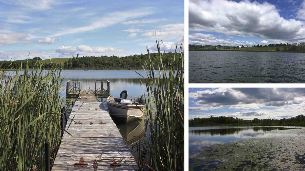
Pour mieux comprendre l’évolution de la qualité de l’eau et de la quantité d’eau dans la RGL, des chercheurs de l’Université Western en Ontario ont étudié les sédiments du lac Barry (44,30765 °N, -77,92137 °W), un petit lac de kettle situé dans la RGL près de Peterborough (Ontario, Canada), sur les terres traditionnelles de la bande des Mississauga, des Hurons-Wendats et des Anishinaabeg (Doyle et coll., 2021). Les variations de la chimie de la matière organique et de certains minéraux dans ces sédiments séquentiellement stratifiés et datés fournissent un enregistrement indirect des changements de la qualité de l’eau et de la quantité d’eau au cours du dernier millénaire. Les résultats obtenus au lac Barry ont été comparés à d’autres enregistrements de sédiments lacustres afin de déterminer si les schémas temporels observés au lac Barry se retrouvaient dans l’ensemble de la RGL. Cet enregistrement d’environ 900 ans permet de différencier les variations naturelles de l’environnement des perturbations plus récentes associées à l’urbanisation et au réchauffement rapide du climat.
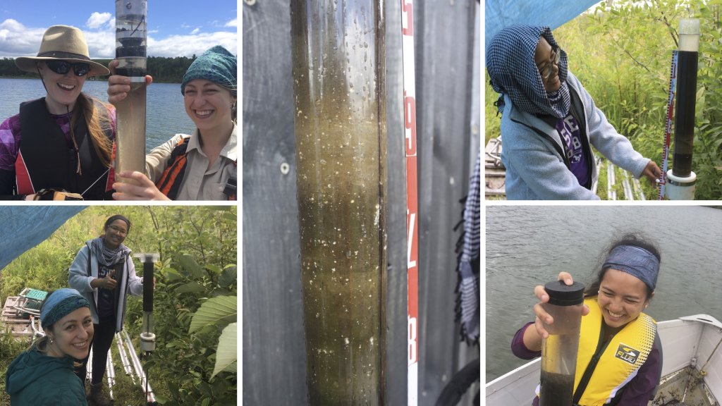
Les chercheurs ont prélevé trois carottes de sédiments de 40 à 50 u centre du lac Barry (Figure 3). Ces carottes ont ensuite été sous-échantillonnées à intervalles de 0,5 cm. La datation radiométrique (210Pb et 14C) a été utilisée pour attribuer des dates à certaines couches de sédiments, et ces dates ont ensuite été interpolées au moyen du progiciel statistique « rbacon » (Blaauw et coll., 2021 ; R Core Development Team, 2023) pour établir la chronologie des sédiments en profondeur. Les auteurs ont ensuite analysé des composants organiques et minéraux spécifiques provenant de couches datées dans les sédiments et ont interprété ces données en termes de changements de la qualité et de la quantité de l’eau au cours des ~900 dernières années.
En résumé, les contributions de Doyle et de ses collègues sont triples :
(1) La qualité de l’eau moderne et la croissance des algues dans le lac Barry sont plus élevées aujourd’hui qu’elles ne l’ont jamais été au cours des ~900 dernières années. Un objectif de restauration approprié consisterait à ramener les concentrations de chlorophylle a aux niveaux antérieurs à 1850 CE.
(2) Les petits lacs, dont on pense généralement qu’ils n’enregistrent que des signaux climatiques locaux, peuvent également enregistrer des schémas climatiques régionaux liés à des processus océaniques et atmosphériques internes (par exemple, AMO et PDO), comme cela a été démontré dans l’est de la RGL et le nord-est des États-Unis.
(3) L’étude de Doyle et de ses collègues souligne l’importance des régimes climatiques régionaux dans le contrôle de l’humidité dans la GLR. Une meilleure compréhension de ces régimes climatiques améliorera notre capacité à prévoir les futures périodes humides et sèches dans cette région économiquement et écologiquement importante.
– By Rebecca M. Doyle, Katrina A. Moser, Fred J. Longstaffe –
The Laurentian Great Lakes of North America are a critical global water resource comprising approximately 1/5th of the liquid freshwater available on the Earth’s surface (Campbell et al., 2015). The area around these lakes, the Great Lakes region (GLR) (37.1 to 56.9 °N, 97.3 to 70 °W), is home to ~40 million residents who depend on this water. In this water-rich region, one might assume that clean freshwater is, and will always be, readily available. Rapid population growth and climate change, however, threaten to reduce water availability through reductions in water quality and quantity in the GLR (Cotner et al., 2017; Bonsal et al., 2019).
In this context, we define water quality as the chemical, physical and biological characteristics of water that determine ecosystem and human health and water quantity as the amount of surface water available for ecosystems, human health, industry and recreation. Phosphate-rich runoff from agricultural fields can fertilizes lakes, leading to harmful algae blooms (Sinha et al., 2017). As populations in and around the GLR rise, governments face increasing pressure to divert water resources away from lakes and towards growing communities (Cotner et al., 2017). Climate change can exacerbate these threats as rising temperatures can encourage algal growth and increase summer droughts that reduce water availability (Nazari-Scharabian et al., 2018). Predicting the effects of climate change on water quantity in the GLR, however, is difficult because we have yet to fully understand the influences of natural internal variability of climate, including the Pacific Decadal Oscillation and Atlantic Multidecadal Oscillation (AMO), on water quantity (Rodysill et al., 2018). To better understand the role of internal ocean and atmospheric processes on climate requires records that extend beyond what is available from instrumental records and measurements.
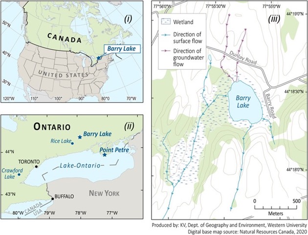
To further understand how water quality and quantity in the GLR are changing, researchers from The University of Western Ontario studied sediments from Barry Lake (44.30765, -77.92137), a small kettle lake situated in the GLR near Peterborough (Ontario, Canada), on the traditional lands of the Mississauga, Huron-Wendat and Anishinaabeg peoples (Doyle et al., 2021; Fig. 1, 2). Variations in the chemistry of organic matter and certain minerals in these sequentially layered and dated sediments provide a proxy record of changes in water quality and quantity over the last millennium. The Barry Lake results were compared with other lake sediment records to determine if time-dependent patterns observed at Barry Lake occurred across the entire GLR. This ~900-year record provides a context for differentiating natural environmental variations from more recent perturbations associated with urbanization and rapid climate warming.
The researchers collected three 40- to 50-cm sediment cores from the centre of Barry Lake (Fig. 3). These cores were then subsampled at 0.5-cm intervals. Radiometric dating (210Pb and 14C) was used to assign dates to certain layers of the sediment, and these dates were then interpolated using the statistical package “rbacon” (Blaauw et al., 2021; R Core Development Team, 2023) to establish the down-core sediment chronology. The authors then analyzed specific organic and mineral components from dated layers in the sediment and interpreted those data in terms of water quality and quantity changes over the last ~900 years.
Changes in water quality were evaluated using sedimentary chlorophyll a, a pigment produced by photosynthetic lifeforms. Sedimentary chlorophyll a content, a sensitive indicator of algal growth, which is closely tied to water quality, was measured using visible near-infrared spectroscopy (VNIRS). Changes in water quantity were inferred by measuring oxygen- and stable carbon-isotope compositions of marl (calcium carbonate precipitated in the lake water, mostly during the summer). These isotopic proxies technically track the balance of evaporation minus precipitation rather than water quantity; however, in small lakes like Barry Lake these variables are closely related.
These proxy records showed that, at Barry Lake, water quality has deteriorated in the modern era (1850 CE to present) but modern water quantity remains typical when compared with past conditions. Chlorophyll a concentration was low and unchanging from 0 to 1850 CE, but rose substantially from 1850 CE to present day, indicating a progressive increase in algal growth. The local census revealed that European settlement around Barry Lake occurred around 1850 CE. European settlers typically converted forests into farmland shortly after arriving, a process that commonly introduced nutrients to the lake and promoted algae growth.
Water quantity (i.e., lake level) in Barry Lake varied substantially over the last millennium with fluctuating values during the warm and dry Medieval Climate Anomaly (1000 to 1300 CE) and higher values during the cool and wet Little Ice Age (1450-1850 CE). Modern (1850 CE to present) values lie between those of these two periods. This finding suggests that, while air temperatures in the GLR are certainly rising, this rapid climate warming has not yet translated to noticeable changes in water quantity at Barry Lake.
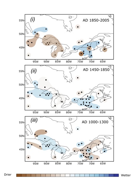
Doyle and coworkers also compared records of water quantity and/or atmospheric moisture across the GLR to assess whether trends observed at Barry Lake were also observed at nearby sites (Fig. 4). The 38 records of interest were divided into three time periods representing the Medieval Warm Period, the Little Ice Age, and the modern period, respectively, and only long-term (e.g., centennial) trends were extracted from the data. We note that most of the proxies used are more sensitive to summer than winter conditions, which may have resulted in a warm-season bias in the interpretation.
This analysis revealed differences between the western-half of the GLR (i.e., west of Lake Ontario) and the eastern-half of the GLR (i.e., east of Lake Ontario) and Northeastern United States (NE US). During the Medieval Climate Anomaly, the eastern half of the GLR/NE US was generally dry, indicating lower water table depths, precipitation amounts, and lake levels. By comparison, many sites in the western half of the GLR were wet. During the Little Ice Age, the entire region was generally wet. In the modern period, much of the western GLR has been dry while the eastern GLR/NE US has been wet.
In general, Doyle and coworkers’ findings correspond with previous studies, particularly for widespread wetness during the Little Ice Age. The west-east dipole in conditions observed during the Medieval Climate Anomaly and the modern period likely result from regional climate patterns related to the Atlantic Multidecadal Oscillation (AMO) and/or the Pacific Decadal Oscillation (PDO). This result suggests that the AMO and PDO are critical regulators of hydroclimate across the GLR.
To summarize, the contributions of Doyle and coworkers are threefold:
(1) Modern water quality/algal growth in Barry Lake is higher today than at any time in the last ~900 years. An appropriate restoration target would be to reduce chlorophyll a concentrations to pre- 1850 CE levels.
(2) Small lakes, which are commonly thought to record only local climate signals, may also record regional climate patterns linked to internal oceanic and atmospheric processes (e.g., AMO and PDO), as demonstrated across the eastern GLR and NE US.
(3) Doyle and coworkers’ study underscores the importance of regional climate patterns in controlling moisture across the GLR. Improving our understanding of these climate patterns will improve our capabilities to predict future wet/dry periods in this economically and ecologically important region.
Rebecca Doyle is presently a Postdoctoral Fellow at the Analytical, Environmental and Geo-Chemistry (AMGC) Research Group at the Vrije Universiteit Brussel (VUB) in Belgium. Her research focuses on using the chemical, physical and biological properties of lake sediments to reconstruct paleoenvironmental conditions over the last 2.6 million years.
Katrina Moser is a professor and Chair of Geography and Environment at The University of Western Ontario, in London, Ontario, Canada. Katrina is a paleolimnologist who uses fossils and biogeochemical signals preserved in lake sediments to study climate change and its impact on lake ecosystems.
Fred J Longstaffe is Distinguished University Professor and Canada Research Chair (Tier 1) in Stable Isotope Science at The University of Western Ontario, in London, Ontario, Canada. Fred uses light stable isotopes to understand interactions across the lithosphere-hydrosphere-biosphere- atmosphere continuum, and to decipher the paleoclimatic, paleoenvironmental and paleoecological information recorded in these isotopic signals.
References
Blaauw, M., Christen, J.A., Lopez, M.A.A., Vazquez, J.E., Gonzales, O.M.V., Belding, T., Theiler, J., Gough, B., Karney, C., 2021. Package “rbacon”. http://cran.rproject.org/web/packages/rbacon/rbacon.pdf
Bonsal, B.R., Peters, D.L., Seglenieks, F., Rivera, A. and Berg, A., 2019. Changes in freshwater availability across Canada. Canada’s Changing Climate Report, pp.261-342.
Campbell, M., Cooper, M.J., Friedman, K. and Anderson, W.P., 2015. The economy as a driver of change in the Great Lakes–St. Lawrence River basin. Journal of Great Lakes Research, 41, pp.69-83.
https://doi.org/10.1016/j.jglr.2014.11.016
Cotner, J.B., Weinke, A.D. and Biddanda, B.A., 2017. Great Lakes: Science can keep them great. Journal of Great Lakes Research, 43(5), pp.916-919. https://doi.org/10.1016/j.jglr.2017.07.002
Doyle, R.M., Liu, Z., Walker, J.T., Hladyniuk, R., Moser, K.A. and Longstaffe, F.J., 2021. A 900-year record of effective moisture in the Laurentian Great Lakes region. Quaternary Science Reviews, 270, p.107174. https://doi.org/10.1016/j.quascirev.2021.107174
Nazari-Sharabian, M., Ahmad, S. and Karakouzian, M., 2018. Climate change and eutrophication: a short review. Engineering, Technology and Applied Science Research, 8(6), p.3668. https://digitalscholarship.unlv.edu/fac_articles/562
R Core Development Team, 2023. R: A Language and Environment for Statistical Computing.
https://www.r-project.org/
Rodysill, J.R., Anderson, L., Cronin, T.M., Jones, M.C., Thompson, R.S., Wahl, D.B., Willard, D.A., Addison, J.A., Alder, J.A., Anderson, K.H., Anderson, L., Barron, J.A., Bernhardt, C.E., Hostetler, S.W., Kehrwald, N.M., Khan, N.S., Richey, J.N., Starratt, S.W., Strickland, L.E., Toomey, M.R., Treat, C. C. and Wingard, G.L., 2018. A North American Hydroclimate Synthesis (NAHS) of the Common Era. Global and Planetary Change, 162, 175-198. https://doi.org/10.1016/j.gloplacha.2017.12.025
barry lake, fred longstaffe, Grands Lacs laurentiens, katrina moser, laurentian great lakes, rebecca doyle, sediment core, sédiments, water quality, water quantity