
Cartographie magnétique marine dans la sous-zone sismique de la baie de Passamaquoddy
– Par John Evangelatos, Karl E. Butler, Jennifer Adam, William A. Morris –
La région de la baie de Passamaquoddy, au sud-ouest du Nouveau-Brunswick et au nord-est du Maine, a connu au moins deux séismes de magnitude 5 et de nombreux autres séismes de magnitude plus faible depuis le début des années 1800 (Halchuk et coll. 2015).
Une compréhension approfondie de la sismicité régionale, bien que pertinente pour les géoscientifiques, est particulièrement importante du point de vue de la sécurité publique, étant donné que la Centrale nucléaire de Point Lepreau est située à 45 km à l’est de St. Andrews, au Nouveau-Brunswick, le long de la côte de la baie de Fundy. Un levé magnétique aéroporté régional effectué en 2001 (Kiss et coll., 2002), avec une garde au sol nominale de 100 m et un espacement des lignes de 200 m’a révélé des coudes (déflexions), reflétant peut-être des ruptures ou des décalages, dans l’anomalie par ailleurs linéaire associée au dyke de l’île Ministers. Nous avons donc émis l’hypothèse que le dyke de l’île Ministers, une intrusion mafique relativement jeune mise en place lors de la rupture naissante du supercontinent Pangea, avait été faillé. De plus, de telles failles potentielles peuvent être actuellement sismogènes. Pour vérifier cette hypothèse, nous avons entrepris de mieux représenter l’anomalie du dyke de l’île Ministers en effectuant des levés magnétiques marins à haute résolution dans la rivière Ste-Croix et dans la partie nord de la baie de Passamaquoddy (Evangelatos et coll. 2024).
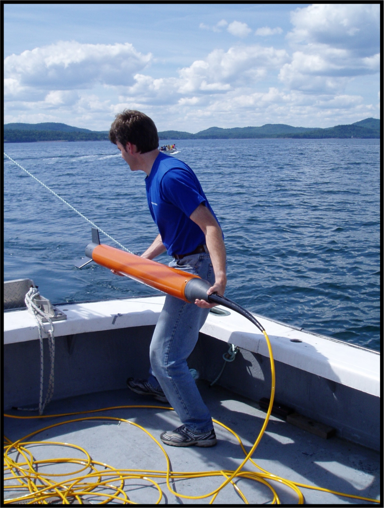
Les données initiales utilisées pour cette étude ont été acquises en 2005 à l’aide d’un navire de recherche en fibre de verre de 13 mètres. Un magnétomètre marin à effet Overhauser SeaSpy (capteur magnétique), prêté par la Commission géologique du Canada, a été utilisé pour mesurer l’intensité du champ magnétique total, tandis qu’un échosondeur à faisceau unique a été utilisé pour la bathymétrie. Le magnétomètre a été remorqué à 30 m derrière le navire (figure 2) à une profondeur d’environ 1 m sous la surface de l’eau. Au total, 113,4 lignes-kilomètres de données ont été acquises.
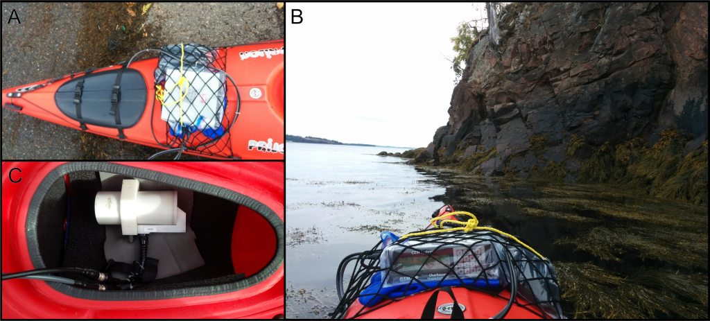
Le levé par bateau a fourni une couverture et une résolution satisfaisantes pour expliquer le comportement de l’anomalie du dyke de l’île Ministers dans la baie de Passamaquoddy (abordé ci-dessous). Dans la rivière Ste-Croix, cependant, la ligne la plus à l’ouest ne laissait entrevoir qu’une rupture et un décalage le long de la tendance du dyke de l’île Ministers — il fallait davantage de données pour dissiper nos doutes! En 2016, l’occasion s’est présentée de réexaminer cette étude. C’est ainsi que le relevé de la rivière Ste-Croix a été étendu vers l’ouest aux eaux peu profondes et intertidales de Brooks Cove, dans le Maine, à l’aide d’un magnétomètre GEM Overhauser monté sur un kayak à deux places (Adam 2017; figure 3). En plus du relevé de Brooks Cove, une ligne du relevé en bateau de 2005 a été relevée à des fins de comparaison et de nivellement. Des stations magnétiques de base ont été déployées sur le rivage pour enregistrer les variations diurnes et temporelles, et des échantillons de roches orientées ont été prélevés sur un affleurement côtier du dyke de l’île Ministers pour mesurer la susceptibilité magnétique et l’aimantation rémanente.
Les données magnétiques marines à haute résolution montrent un décalage latéral droit de 370 m du dyke de l’île Ministers le long de la faille d’Oak Bay, en aval de la rivière Ste-Croix — une déduction qui était ambiguë dans le levé aéromagnétique de 2001. Ce mouvement est opposé au déplacement latéral gauche de la faille qui est préservé dans des roches beaucoup plus anciennes (de l’ère paléozoïque) trouvées sur la terre ferme au nord, au fond d’Oak Bay. Cette inversion de mouvement peut être liée à la compression mésozoïque également observée ailleurs dans le bassin du rift de Fundy (Withjack et coll. 1995; Waldron et coll., 2005). Bien que l’on ne sache pas si le décalage du dyke de l’île Ministers est lié à l’activité sismique moderne, la position révisée de la faille d’Oak Bay sous l’estuaire de la rivière Ste-Croix offre un point de mire pour de futures études néotectoniques utilisant, par exemple, le profilage acoustique du fond pour obtenir des images des sédiments marins du Quaternaire. En outre, les solutions du plan de faille pour les tremblements de terre à proximité de la faille d’Oak Bay peuvent être réexaminées afin de déterminer si une composante de glissement latéral droit, compatible avec le décalage du dyke de l’île Ministers observé, est observée. En revanche, les légères courbures et bifurcations du dyke de l’île Ministers observées plus à l’ouest dans la baie de Passamaquoddy semblent être des caractéristiques de mise en place originales et/ou une conséquence des changements de la profondeur du substratum rocheux ainsi que de légères déviations de la verticalité du dyke. La modélisation du dyke dans cette zone ne montre aucune preuve qu’il a été décalé par une faille — du moins pas à la résolution de notre étude.
Les interprétations géologiques issues de notre travail ont été rendues possibles par l’amélioration de la résolution spatiale offerte par les levés marins ciblant des régions d’intérêt dans des cartes géophysiques à plus faible résolution. Nous pensons que les nouvelles technologies récemment développées, telles que les véhicules aériens sans pilote (UAV) et les véhicules sous-marins autonomes (AUV), offrent de nouvelles possibilités aux chercheurs en sciences de la terre et des océans et pour des applications dans les études d’ingénierie.
– By John Evangelatos, Karl E. Butler, Jennifer Adam, William A. Morris –
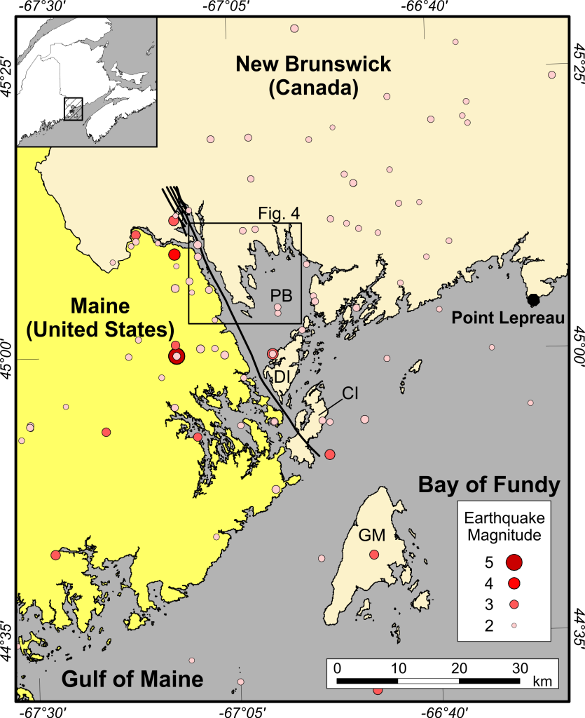
The Passamaquoddy Bay region, southwest New Brunswick and northeast Maine, has experienced at least two earthquakes of magnitude 5 and many more earthquakes of smaller magnitude since the early 1800s (Halchuk et al. 2015). A thorough understanding of the regional seismicity, while relevant to geoscientists, is particularly important from a public safety standpoint considering that the Point Lepreau Nuclear Generating Station is located 45 km east of St. Andrews, New Brunswick, along the Bay of Fundy coastline. As shown in Figure 1, there appears to be some clustering of known epicentres west of the Oak Bay Fault, although this distribution is difficult to interpret due to the high error inherent in locating pre-instrumental earthquakes and inadequate seismographic coverage up until the early 1980s. Geologists sought to find evidence of recent (neotectonic) activity along the Oak Bay Fault and other faults in the region, but results were inconclusive (e.g., Kelley et al. 1989, Burke and Stringer 1993). A regional airborne magnetic survey flown in 2001 (Kiss et al., 2002), with a nominal ground clearance of 100 m and line spacing of 200 m, revealed kinks (deflections), possibly reflecting breaks or offsets, in the otherwise linear anomaly associated with the Ministers Island dyke (MID). We therefore hypothesized that the MID, a relatively young mafic intrusion emplaced during the incipient breakup of the Pangea supercontinent, had been faulted. Moreover, such potential faults may be currently seismogenic. To test this hypothesis, we set out to better image the MID anomaly by conducting high resolution marine magnetic surveys in the St. Croix River and the northern part of Passamaquoddy Bay (Evangelatos et al. 2024).
Interestingly, this marine magnetic survey was originally conceived as a way to prepare for a similar survey in a remote lake in central Quebec to investigate the Ile Rouleau impact structure (Evangelatos et al. 2009). The results however, led to richer geological insights than expected. As such, we encourage readers to optimize every opportunity to do science, even when it just involves testing equipment or new methods.
The initial data used for this study were acquired in 2005 using a 13 m fibreglass research vessel. A SeaSpy Overhauser-effect marine magnetometer (magnetic sensor), on loan from the Geological Survey of Canada, was used to measure the total magnetic field intensity, while a single-beam echo-sounder was used for bathymetry. The magnetometer was towed 30 m behind the vessel (Figure 2) at a depth of ~1 m below the water surface. In total, 113.4 line-kilometers of data were acquired.
The boat survey provided satisfactory coverage and resolution for explaining the behaviour of the MID anomaly in Passamaquoddy Bay (discussed below). In the St. Croix River, however, the westernmost line only hinted at a break and offsetting along the trend of the MID– more data was needed to quash our doubts! An opportunity arose in 2016 to revisit this study. And so, the St. Croix River survey was extended westward into the shallow and intertidal waters of Brooks Cove, Maine, using a GEM Overhauser magnetometer mounted on a two-person kayak (Adam 2017; Figure 3). In addition to surveying Brooks Cove, a line from the 2005 boat survey was re-surveyed for comparison and levelling purposes. Stationary magnetic base stations were deployed on shore to record diurnal/temporal variations, and oriented rock samples were collected from a coastal outcrop of the MID to measure magnetic susceptibility and remanent magnetization.
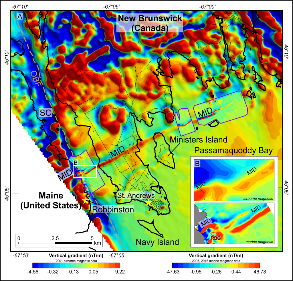
The raw magnetic field measurements were filtered to remove minor random noise, then corrected for changes in the ambient magnetic field caused by ionospheric activity (i.e., diurnal/temporal variations monitored by base station magnetometers we had set up onshore). Finally, the International Geomagnetic Reference Field (IGRF), representing the Earth core’s contribution to the total magnetic field was subtracted. The remainder is referred to as the total field magnetic anomaly (TFMA) and represents magnetic fields created by magnetic (especially magnetite-rich) rock in Earth’s crust. Despite this treatment, line-effects persisted in the data. We attributed this noise to tides, which continuously varied the height of the magnetometer above magnetic sources below the seafloor. In particular, the magnetometer could be almost 6 m closer to the top of the MID at low tide than at high tide. The TFMA data were tie-line levelled to suppress these artefacts.
The results of the high resolution marine magnetic surveys are best illustrated using the vertical gradient of the magnetic field (Figure 4), which emphasizes shallow sources (such as bedrock contacts) and can be calculated from the TFMA by virtue of it (like gravity) being a potential field. Comparing the airborne data to the much more detailed marine data demonstrates the benefits of acquiring high resolution data– which is primarily due to the reduced source-to-sensor separation (1 – 60 m of water vs 100-160 m of air plus water), though also because of the finer line spacing (50 or 100 m vs 200 m).
Forward modelling of the data, constrained by water depths, rock properties, and dyke geometry from onshore field studies, was undertaken to characterize the MID. Those quantitative modelling results, combined with observed variations in the strength, trend and character of the dyke anomaly (Figure 4) led to several conclusions. For the St. Croix River survey, the results and their interpretation are as follows:
- the MID anomaly is better described as two linear magnetic highs aligned sub‑parallel to one another, suggesting that the MID segmented into a thinner northern dykelet and a main southern dyke;
- a discontinuity in the MID anomaly east of Brooks Cove is apparent in the magnetic mapping and supported by the modelling;
- there is a ~370 m of right-lateral offset between the MID anomaly on either side of the inferred Oak Bay Fault below the St. Croix River;
- an abrupt weakening of the MID anomaly at the Oak Bay Fault is due to demagnetization in the fault zone as a result of geochemical alteration;
- the MID anomaly is curved into the Oak Bay Fault zone, suggestive of clockwise drag folding during post-emplacement right-lateral movement of the fault;
- the trace of the Oak Bay Fault has been redrawn as the demarcation between two domains of contrasting magnetic character; and
- a crudely annular and irregular anomaly to the south of the MID in Brooks Cove is caused by the Red Beach Granite.
For Passamaquoddy Bay:
- the speculative Big Bay Fault, originally conceived to explain a linear trend in pockmarks along the seabed, does not show any evidence of movement after emplacement of the MID, consistent with the findings of a low resolution marine magnetic survey from 1988 (Burke and Stinger 1993);
- as in the St. Croix River, the MID anomaly segments into two parts, in eastern Passamaquody Bay, that diverge eastwardly;
- while the amplitude of the southern segment weakens and disappears rather abruptly, the northern segment gradually thins out 1.2 km to the east, according to our modelling;
- this configuration is indicative of sinistral stepover emplacement of the dyke (i.e., an original feature, unrelated to faulting), also observed in genetically related dykes elsewhere in northeastern North America (McHone et al. 2022); and
- at the resolution of our survey, there is no evidence of post-emplacement faulting of the MID in Passamaquoddy Bay that could account for elevated levels of seismicity in the region.
To conclude, high resolution marine magnetic data show a 370 m right-lateral offset of the Ministers Island dyke along the Oak Bay Fault, below the St. Croix River– an inference that was ambiguous in the 2001 aeromagnetic survey. This sense of motion is opposite to left-lateral displacement of the fault that is preserved in much older (Paleozoic Era) rocks found onshore to the north at the head of Oak Bay. Such reversal of motion may be connected to Mesozoic compression also observed elsewhere in the Fundy rift basin (Withjack et al. 1995; Waldron et al. 2005). While it is unclear if offsetting of the MID is related to modern seismic activity, the revised position of the Oak Bay Fault beneath the St. Croix River estuary offers a focus for future neotectonic investigations using, for example, acoustic sub-bottom profiling to image marine Quaternary sediments. In addition, fault plane solutions for earthquakes near Oak Bay Fault can be revisited to determine whether a right-lateral strike-slip component, consistent with the observed MID offset, is observed. In contrast, slight bends and bifurcation of the MID observed farther to the west in Passamaquoddy Bay appear to be original emplacement features and/or a consequence of changes in depth-to-bedrock together with slight deviations of the dyke from verticality. Modelling of the dyke in that area show no evidence that it has been offset by faulting– at least not at the resolution of our survey.
The geological interpretations stemming from our work were enabled by the improved spatial resolution afforded by the marine surveys targeting regions of interest in lower resolution geophysical maps. Newer recently developed technologies, like cost-effective unmanned aerial vehicles (UAVs) and autonomous underwater vehicles (AUVs), we believe offer new opportunities for researchers in the Earth and Ocean sciences and for applications in engineering studies
John (Yanni) Evangelatos earned a B.Sc. (2005) from McGill University, a M.Sc. (2008) from the University of New Brunswick, and a Ph.D. (2018) from Dalhousie University. John was a contractor/consultant for clients in industry (mineral and petroleum), government, and academia, and has been employed as a Geophysicist with the Ontario Geological Survey since 2022.
Karl Butler, Ph.D., P.Geo., P.Eng., is a Professor in the Department of Earth Sciences at the University of New Brunswick. His research emphasizes use and development of near-surface geophysical methods for engineering, hydrogeological and geological applications.
Jennifer Adam graduated with honours from the University of New Brunswick with a double major in Earth Science and Physics. Following her scientific education, she earned a Juris Doctor and is currently practicing law.
William Morris graduated from the University of Leeds with a B.Sc. Hons in Earth Sciences and then completed a Ph.D. with the Open University. After supervising several graduate students at McMaster University, William is now Professor Emeritus with expertise in potential field geophysics, borehole magnetics, palaeomagnetics, and physical rock property analysis.
References
Adam, J., 2017. Inferring post-Jurassic movement of the Oak Bay Fault through acquisition and modelling of magnetic profiles across the Ministers Island Dyke in Brooks Cove, Maine, USA. B.Sc. Honours thesis. University of New Brunswick, Fredericton, N.B., Canada.
Burke, K.B.S., and Stringer, P. 1993. A search for neotectonic features in the Passamaquoddy Bay region, southwestern New Brunswick, Current Research, Part D. Geological Survey of Canada. Paper 93 1D: 93-102.
Evangelatos, J., Butler, K.E., Adam, J., and Morris, W.A. 2024. New insights on faulting in southwest New Brunswick and northeast Maine based on marine magnetic mapping of the Ministers Island dyke. Canadian Journal of Earth Sciences, 61: 187-204.
Evangelatos, J., Butler, K.E., and Spray, J.G. 2009. A marine magnetic study of a carbonate-hosted impact structure: Ile Rouleau, Canada. Geophysical Journal International, 179 (1): 171–181.
Halchuk, S., Allen, T.I., Rogers, G.C., and Adams, J. 2015. Seismic Hazard Earthquake Epicentre File (SHEEF2010) used in the Fifth Generation Seismic Hazard Maps of Canada. Geological Survey of Canada, Open File 7724.
Kelley, J.T., Belknap, D.F., Shipp, R.C., and Miller, S. B. 1989. An investigation of neotectonic activity in coastal Maine by seismic reflection methods. Neotectonics of Maine, Maine Geological Survey Bulletin, 40: 157-204.
Kiss F., Potvin J., Coyle, M., and McLeod, M. 2002. Magnetic first vertical derivative map, Geological Survey of Canada, St. George, New Brunswick: NTS 21 G/02, MP 2002-1A, Open File 4207, scale 1:50 000.
McHone, G.J., Barr, S.M., and Jourdan, F. 2022. Petrology and age of the Lepreau River Dyke, southern New Brunswick, Canada: source of the end-Triassic Fundy Group basalts. Canadian Journal of Earth Sciences, 59: 12-28.
Waldron, J.W.F., Barr, S.M., Park, A., F., White, C.E., and Hibbard, J., 2015. Late Palaeozoic strike-slip faults in Maritimes Canada and their role in the reconfiguration of the northern Appalachians orogen. Tectonics, 34: 1661–1684.
Withjack, M.O., Olsen, P.E., and Schlische, R.W. 1995. Tectonic evolution of the Fundy rift basin, Canada: evidence of extension and shortening during passive margin development. Tectonics, 14(2): 390-405.
bay of fundy, earthquake, Jennifer Adam, John Evangelatos, Karl E. Butler, Marine magnetic mapping, New Brunswick, Passamaquoddy Bay, William A. Morris